IMAGES TAKEN NEAR TO
Mill Lane, CHALFONT ST. GILES, HP8 4NP
Introduction
This page details the photographs taken nearby to Mill Lane, HP8 4NP by members of the Geograph project.
The Geograph project started in 2005 with the aim of publishing, organising and preserving representative images for every square kilometre of Great Britain, Ireland and the Isle of Man.

There are currently over 7.5m images from over14,400 individuals and you can help contribute to the project by visiting https://www.geograph.org.uk
Image Map
Images are licensed for reuse under creativecommons.org/licenses/by-sa/2.0
Notes
- Clicking on the map will re-center to the selected point.
- The higher the marker number, the further away the image location is from the centre of the postcode.
Image Listing (10 Images Found)
Images are licensed for reuse under creativecommons.org/licenses/by-sa/2.0
Image
Details
Distance
1
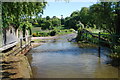
Mill Farm Ford, Chalfont St Giles
This ford is found beside the mill at Chalfont St Giles.
Image: © John Walton
Taken: 2 Jun 2013
0.02 miles
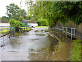
3
Chalfont St Giles: Mill Farm ford
A braid of the River Misbourne passes over Mill Lane here, although it was dry on the day that the photograph was taken and appeared to have been so for some time. The footbridge on the right enables a potentially dry passage.
Image: © Nigel Cox
Taken: 31 Dec 2008
0.02 miles
4
Ford on Mill Lane, Chalfont St. Giles
A ford of the Misbourne.
Image: © Robin Webster
Taken: 18 Jun 2016
0.02 miles
5
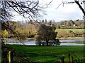
Flooded fields in the Misbourne valley
The River Misbourne is a double name-bourne means river.
Image: © Bikeboy
Taken: 23 Mar 2014
0.11 miles
7
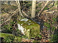
Old Milestone by the A413 Amersham Road
Carved stone post by the A413, in parish of Chalfont St Giles (Chiltern District), Amersham Road; opposite gates to Misbourne House, 15m North of Mill Lane turning, in ditch, amongst nettles in remains of hedge; at back of cut verge, on West side of road. Amersham limestone square, erected by the Wendover & Oak Lane turnpike trust in the 18th century. Broken.
Inscription reads:-
LONDON
23
CHALFONT
ST GILES
Grade II listed.
List Entry Number: 1125001 https://historicengland.org.uk/listing/the-list/list-entry/1125001
Milestone Society National ID: BU_LC23
Image: © A Rosevear & J Higgins
Taken: 1 Mar 2004
0.15 miles
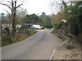
8
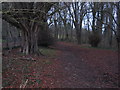
South Bucks Way
South Bucks Way nearing Chalfont St Giles
Image: © Shaun Ferguson
Taken: 30 May 2008
0.18 miles
9
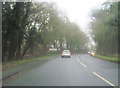
A413 entering Chalfont St Giles southbound
Image: © John Firth
Taken: 17 Mar 2012
0.21 miles
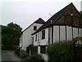
10
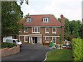
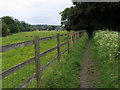
House on Dodds Lane, Chalfont St Giles
There are a number of large new houses along the north side of the lane, older houses on the south side.
Image: © David Hawgood
Taken: 22 May 2008
0.24 miles