IMAGES TAKEN NEAR TO
Three Households, CHALFONT ST. GILES, HP8 4LW
Introduction
This page details the photographs taken nearby to Three Households, HP8 4LW by members of the Geograph project.
The Geograph project started in 2005 with the aim of publishing, organising and preserving representative images for every square kilometre of Great Britain, Ireland and the Isle of Man.

There are currently over 7.5m images from over14,400 individuals and you can help contribute to the project by visiting https://www.geograph.org.uk
Image Map
Images are licensed for reuse under creativecommons.org/licenses/by-sa/2.0
Notes
- Clicking on the map will re-center to the selected point.
- The higher the marker number, the further away the image location is from the centre of the postcode.
Image Listing (8 Images Found)
Images are licensed for reuse under creativecommons.org/licenses/by-sa/2.0
Image
Details
Distance
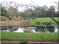
1
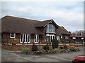
Oakland Park Golf Club
This is a privately owned golf club at Three Households situated at the western edge of Chalfont St Giles.
Image: © David Squire
Taken: 5 Dec 2005
0.06 miles
2
Chalfont St Giles village boundary at Butlers Cross
Image: © Colin Pyle
Taken: 27 Feb 2016
0.09 miles
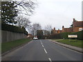
4
Three Households at the end of Twitchells Lane
Image: © David Howard
Taken: 8 Oct 2015
0.15 miles
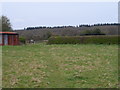
6
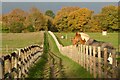
Pasture, Seer Green
A footpath heads through paddocks to reach Butler's Cross and the western edge of Chalfont St Giles.
Image: © Andrew Smith
Taken: 20 Nov 2022
0.23 miles
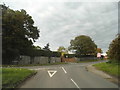
7
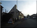
Road works on Three Households, Chalfont St Giles
Image: © David Howard
Taken: 28 Feb 2013
0.23 miles
8
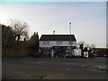
Shops on Three Households, Chalfont St Giles
Image: © David Howard
Taken: 28 Feb 2013
0.24 miles