IMAGES TAKEN NEAR TO
Gorelands Lane, CHALFONT ST. GILES, HP8 4AB
Introduction
This page details the photographs taken nearby to Gorelands Lane, HP8 4AB by members of the Geograph project.
The Geograph project started in 2005 with the aim of publishing, organising and preserving representative images for every square kilometre of Great Britain, Ireland and the Isle of Man.

There are currently over 7.5m images from over14,400 individuals and you can help contribute to the project by visiting https://www.geograph.org.uk
Image Map
Images are licensed for reuse under creativecommons.org/licenses/by-sa/2.0
Notes
- Clicking on the map will re-center to the selected point.
- The higher the marker number, the further away the image location is from the centre of the postcode.
Image Listing (10 Images Found)
Images are licensed for reuse under creativecommons.org/licenses/by-sa/2.0
Image
Details
Distance
1
Old Shire Lane, Chalfont St Peter
Ivy covered trees either side of the narrow lane with Hertfordshire on the left, Buckinghamshire on the right. View from the junction with Gorelands Lane.
Image: © David Hawgood
Taken: 17 Feb 2006
0.09 miles
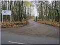
2
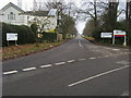
Main entrance to Bucks new University
Main entrance to Bucks new University Chalfont Campus on Newland Park
Image: © Shaun Ferguson
Taken: 29 Nov 2008
0.19 miles
4
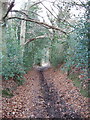
Old Shire Lane beside Newland Park, Chalfont St Giles
The bridleway, bordered by holly and beech trees, is the boundary between Hertfordshire and Buckinghamshire. It is on the east of Newland Park, which contains an open air museum and the Chalfont Campus of Buckinghamshire Chilterns University College.
Image: © David Hawgood
Taken: 17 Feb 2006
0.20 miles
6
Minor entrance to Bucks new university
Minor entrance to Bucks new university at Chalfont Campus Newland Park
Image: © Shaun Ferguson
Taken: 29 Nov 2008
0.22 miles
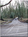
7
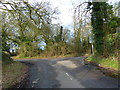
Junction of Brawlings Lane and Gorelands Lane
Image: © Alexander P Kapp
Taken: 2 Feb 2013
0.24 miles
8
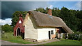
Leagrave Cottages, Chiltern Open Air Museum
The building started life as an 18th century barn in Leagrave, Bedfordshire. The barn was converted into cottages in the 1770s.
Although it was a listed building, permission was given for demolition in the 1980s because it was unfit for human habitation. It was donated to the Museum.
Image: © Mark Percy
Taken: 17 Sep 2017
0.24 miles
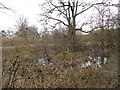
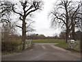
9
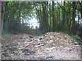
Chalfont St Peter: Former entrance to Newland Park
Two and a half years on from Shaun's Image and this entrance to Newland Park from Gorelands Lane has been abandoned to be taken over by fly-tipping. The road from here eastwards to Maple Cross seems to have particularly attracted this activity. Please see Image and Image
Image: © Nigel Cox
Taken: 22 May 2011
0.24 miles
10
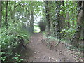
Chalfont St Peter: Old Shire Lane
This is the view looking north along Old Shire Lane which forms the county boundary between Hertfordshire to the right and Buckinghamshire to the left. The woodlands on either side of the lane are two of the Five Plantations. Unlike Image Old Shire Lane through here is not a driveable asphalted road, but is marked on the Ordnance Survey 1:25,000 scale maps with green diamonds indicating a "Recreational Route".
Image: © Nigel Cox
Taken: 22 May 2011
0.24 miles