IMAGES TAKEN NEAR TO
Pomeroy Close, AMERSHAM, HP7 9BW
Introduction
This page details the photographs taken nearby to Pomeroy Close, HP7 9BW by members of the Geograph project.
The Geograph project started in 2005 with the aim of publishing, organising and preserving representative images for every square kilometre of Great Britain, Ireland and the Isle of Man.

There are currently over 7.5m images from over14,400 individuals and you can help contribute to the project by visiting https://www.geograph.org.uk
Image Map
Images are licensed for reuse under creativecommons.org/licenses/by-sa/2.0
Notes
- Clicking on the map will re-center to the selected point.
- The higher the marker number, the further away the image location is from the centre of the postcode.
Image Listing (7 Images Found)
Images are licensed for reuse under creativecommons.org/licenses/by-sa/2.0
Image
Details
Distance
1
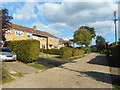
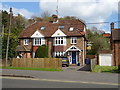
Highmoor, Amersham
On the slope between Old Amersham and Amersham on the Hill.
Image: © Des Blenkinsopp
Taken: 13 Sep 2018
0.14 miles
2
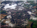
Amersham from the air
Viewed from a Heathrow bound flight from Glasgow.
Image: © Thomas Nugent
Taken: 9 Oct 2011
0.22 miles
3
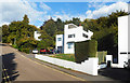
Sun Houses, Highover Park, Amersham
A set of beautiful 1930s houses on a hillside setting between new and old Amersham.
One was recently on the market, and this is from the estate agent's blurb :-
" A stunning grade ii listed detached house designed by the renowned architectural partnership Connell & Ward, early exponents of the modernist movement in the 1930’s, strongly influenced by the French modernist Le Corbusier. There are five ‘sun houses’ built on the slopes leading to the famous High & Over House. These are believed to be amongst the first modernist houses built in Britain and have featured in books, tv programmes and journals covering significant buildings of the 20th century, together with those on Metroland immortalised in Sir John Betjeman’s poetry."
The last sentence is rather disingenuous, as Betjeman was actually quite rude about these places.
Image: © Des Blenkinsopp
Taken: 13 Sep 2018
0.22 miles
4
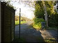
Public Footpath out onto Stanley Hill Avenue
Enclosed public footpath comes out onto Stanley Hill Avenue at Amersham Common. This is on the route of the London Green Belt Way.
Image: © Sean Davis
Taken: 13 Mar 2011
0.22 miles
6
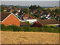
Farmland and houses, Amersham
Looking across to houses on First Avenue from the footpath connecting Station Road and the Old Town. The crop is barley.
Image: © Andrew Smith
Taken: 1 Jul 2009
0.24 miles
7
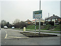
London Road west ( A395) at A413 roundabout
Image: © John Firth
Taken: 17 Mar 2012
0.24 miles