IMAGES TAKEN NEAR TO
Missenden Road, AMERSHAM, HP7 0RL
Introduction
This page details the photographs taken nearby to Missenden Road, HP7 0RL by members of the Geograph project.
The Geograph project started in 2005 with the aim of publishing, organising and preserving representative images for every square kilometre of Great Britain, Ireland and the Isle of Man.

There are currently over 7.5m images from over14,400 individuals and you can help contribute to the project by visiting https://www.geograph.org.uk
Image Map
Images are licensed for reuse under creativecommons.org/licenses/by-sa/2.0
Notes
- Clicking on the map will re-center to the selected point.
- The higher the marker number, the further away the image location is from the centre of the postcode.
Image Listing (11 Images Found)
Images are licensed for reuse under creativecommons.org/licenses/by-sa/2.0
Image
Details
Distance
1
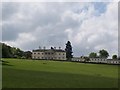
Shardloes Mansion
This is Shardloes, an 18th century mansion which is now flats and apartments. You can read more about it at the following website: http://www.amersham.org.uk/shardeloes.htm
Image: © Balraj Gill
Taken: 10 May 2009
0.03 miles

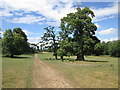
5
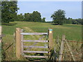
The South Bucks Way in Shardeloes Park
Well marked path on a beautiful day
Image: © Pip Rolls
Taken: 23 Aug 2005
0.17 miles
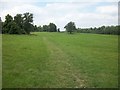
6
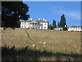
Looking toward Shardeloes from the A413
Shardeloes is a country house built between 1758 and 1766 for William Drake, MP for Amersham. The house has been converted into private flats.
Image: © Bikeboy
Taken: 23 Mar 2014
0.18 miles
10
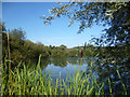
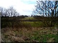
Top End of the Lake Now
At one time Shardeloes Park lake would have continued off to the left, but encroaching willow scrub has grown over part of what used to be open water.
Image: © Des Blenkinsopp
Taken: 4 Sep 2013
0.21 miles