IMAGES TAKEN NEAR TO
Magpie Lane, AMERSHAM, HP7 0LU
Introduction
This page details the photographs taken nearby to Magpie Lane, HP7 0LU by members of the Geograph project.
The Geograph project started in 2005 with the aim of publishing, organising and preserving representative images for every square kilometre of Great Britain, Ireland and the Isle of Man.

There are currently over 7.5m images from over14,400 individuals and you can help contribute to the project by visiting https://www.geograph.org.uk
Image Map
Images are licensed for reuse under creativecommons.org/licenses/by-sa/2.0
Notes
- Clicking on the map will re-center to the selected point.
- The higher the marker number, the further away the image location is from the centre of the postcode.
Image Listing (17 Images Found)
Images are licensed for reuse under creativecommons.org/licenses/by-sa/2.0
Image
Details
Distance
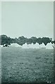
2
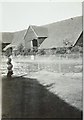
Barn and pond on Bowers Farm in 1928
Photographed by my father George Baker while he was staying in a Mytchett OTC (Officer Training Corps) camp in a field on the farm. I have guessed that the month was August.
Image: © George Baker
Taken: Unknown
0.06 miles
3
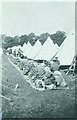
Army camp at Bowers Farm in 1928
Photographed by my father George Baker while he was staying in the camp. From an aerial perspective, it seems probable that the camp was based in the field to the northwest of the farm as it is, today, bounded by tall trees on its western boundary. My father was 17 at the time he took the photograph and attending Image which had a CCF (Combined Cadet Force) and would have organised a summer camp for boys who wished to attend, probably in August. He identified this view as kit inspection, Mytchett OTC (Officers Training Corps) camp so I assume he had attained this rank. Bowers Farm would have been within easy reach of the school, bearing in mind that the roads would not have had the surfaces we are used to nowadays.
Image: © George Baker
Taken: Unknown
0.15 miles
4
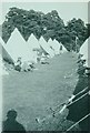
Army camp at Bowers Farm in 1928
Photographed by my father George Baker while he was staying in the camp. From an aerial perspective, it seems probable that the camp was based in the field to the northwest of the farm as it is, today, bounded by tall trees on its western boundary. My father was 17 at the time he took the photograph and attending Image which had a CCF (Combined Cadet Force) and would have organised a summer camp for boys who wished to attend, probably in August. He identified this view as The Lines, Mytchett OTC (Officers Training Corps) camp so I assume he had attained this rank. Bowers Farm would have been within easy reach of the school, bearing in mind that the roads would not have had the surfaces we are used to nowadays.
Image: © George Baker
Taken: Unknown
0.15 miles
5
Army camp at Bowers Farm in 1928
Photographed by my father George Baker while he was staying in the camp. From an aerial perspective, it seems probable that the camp was based in a field to the northwest of the farm as it is, today, bounded by tall trees on its western boundary. My father was 17 at the time he took the photograph and attending Image which had a CCF (Combined Cadet Force) and would have organised a summer camp for boys who wished to attend, probably in August. His identification of the location mentions Mytchett OTC, which stands for Officers Training Corps, so I assume he had reached this rank. Bowers Farm would have been within easy reach of the school, bearing in mind that the roads would not have had the surfaces we are used to nowadays.
Image: © George Baker
Taken: Unknown
0.15 miles
6
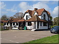
The Harte & Magpies public house
On the A355
Image: © JThomas
Taken: 13 Apr 2019
0.21 miles
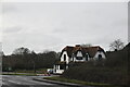
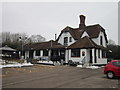
8
The Harte and Magpies
Formerly the Mulberry Bush, but before that, and for a long time, The Magpies.
Image: © Robin Webster
Taken: 27 Mar 2015
0.21 miles
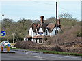
10
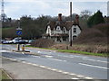
Mulberry Bush
On the A355 at the southern of the two Coleshill turns.
Image: © Andrew Smith
Taken: 9 Apr 2006
0.21 miles