IMAGES TAKEN NEAR TO
High Street, AMERSHAM, HP7 0HR
Introduction
This page details the photographs taken nearby to High Street, HP7 0HR by members of the Geograph project.
The Geograph project started in 2005 with the aim of publishing, organising and preserving representative images for every square kilometre of Great Britain, Ireland and the Isle of Man.

There are currently over 7.5m images from over14,400 individuals and you can help contribute to the project by visiting https://www.geograph.org.uk
Image Map
Images are licensed for reuse under creativecommons.org/licenses/by-sa/2.0
Notes
- Clicking on the map will re-center to the selected point.
- The higher the marker number, the further away the image location is from the centre of the postcode.
Image Listing (16 Images Found)
Images are licensed for reuse under creativecommons.org/licenses/by-sa/2.0
Image
Details
Distance
3
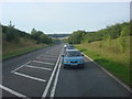
South Bucks Way under Old Amersham Bypass
This is where the South Bucks Way long-distance path and the River Misbourne go under the busy A413 (Amersham Bypass).
Image: © Sean Davis
Taken: 13 Mar 2011
0.18 miles

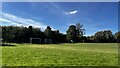
5
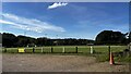
Clubhouse, Spratley's Meadow football ground
Image: © Bryn Holmes
Taken: 17 Oct 2023
0.19 miles
6
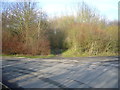
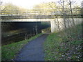
Enclosed Path from Shardeloes towards Old Amersham
This enclosed footpath, from the entrance to Shardeloes, goes through a tunnel under the A413, next to the River Misbourne (see https://www.geograph.org.uk/photo/6426063 ) and on towards Old Amersham. It is on the South Bucks Way and the London Green Belt Way.
Image: © Sean Davis
Taken: 13 Mar 2011
0.19 miles
7
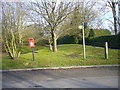
Old Postbox & South Bucks Way sign at Entrance to Shardeloes
This old Royal Mail postbox & South Bucks Way sign are at the entrance to the Shardeloes Estate near Old Amersham. This is also on the route of the London Green Belt Way.
Image: © Sean Davis
Taken: 13 Mar 2011
0.19 miles
9
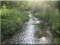
River Misbourne near Shardeloes
A few rays of sunshine penetrate the dense scrub as the clear River Misbourne flows downstream towards Amersham Old Town.
Image: © Nigel Cox
Taken: 2 Jun 2010
0.20 miles
10

River Misbourne above A413 near Old Amersham
A contemporary image at this location http://www.geograph.org.uk/photo/1895757 shows the river corridor here has become densely vegetated by trees and bushes. This section of the Misbourne downstream from Shardeloes Lake has dried-out several times over the last two decades. These periods include autumn 1990-spring 1993, summer 1996-autumn 1997 and autumn 2006.
Image: © David Leeming
Taken: 10 Apr 1997
0.21 miles