IMAGES TAKEN NEAR TO
Bell Lane, AMERSHAM, HP6 6PG
Introduction
This page details the photographs taken nearby to Bell Lane, HP6 6PG by members of the Geograph project.
The Geograph project started in 2005 with the aim of publishing, organising and preserving representative images for every square kilometre of Great Britain, Ireland and the Isle of Man.

There are currently over 7.5m images from over14,400 individuals and you can help contribute to the project by visiting https://www.geograph.org.uk
Image Map
Images are licensed for reuse under creativecommons.org/licenses/by-sa/2.0
Notes
- Clicking on the map will re-center to the selected point.
- The higher the marker number, the further away the image location is from the centre of the postcode.
Image Listing (7 Images Found)
Images are licensed for reuse under creativecommons.org/licenses/by-sa/2.0
Image
Details
Distance
2
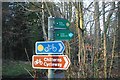
Cycle & Footpath signs Bell Lane
Chilterns Cycleway, public footpath and public bridleway signs from Bell Lane into West Wood at Little Chalfont. This is on the route of the London Green Belt Way which follows the public footpath through the wood on the way to Latimer.
Image: © Sean Davis
Taken: 13 Mar 2011
0.12 miles
3
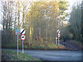
Chiltern Cycleway crosses Bell Lane
Chiltern Cycleway crosses Bell Lane from Forest Cottages into West Wood.
Image: © Sean Davis
Taken: 13 Mar 2011
0.12 miles
4
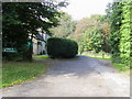
Footpath by Forest Cottages
Off Bell Lane footpath by Forest Cottages heading into Ladies Arbour
Image: © Shaun Ferguson
Taken: 3 Oct 2008
0.13 miles
5
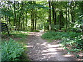
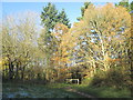
Path into Chiltern Forest
Wide public footpath from Bell Lane into West Wood at Chiltern Forest.
Image: © Sean Davis
Taken: 28 Jul 2007
0.14 miles
6
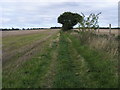
Footpath to Raans Farm
Off Bell Lane footpath to Raans Farm
Image: © Shaun Ferguson
Taken: 3 Oct 2008
0.22 miles
7
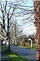
Beechwood Avenue
It seems as though these trees are pollarded frequently in a desirable road just 10 minutes walk from the Metropolitan line.
Image: © Graham Horn
Taken: 20 Jan 2009
0.25 miles