IMAGES TAKEN NEAR TO
Chesham Road, AMERSHAM, HP6 5HA
Introduction
This page details the photographs taken nearby to Chesham Road, HP6 5HA by members of the Geograph project.
The Geograph project started in 2005 with the aim of publishing, organising and preserving representative images for every square kilometre of Great Britain, Ireland and the Isle of Man.

There are currently over 7.5m images from over14,400 individuals and you can help contribute to the project by visiting https://www.geograph.org.uk
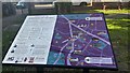
Image Map
Images are licensed for reuse under creativecommons.org/licenses/by-sa/2.0
Notes
- Clicking on the map will re-center to the selected point.
- The higher the marker number, the further away the image location is from the centre of the postcode.
Image Listing (137 Images Found)
Images are licensed for reuse under creativecommons.org/licenses/by-sa/2.0
Image
Details
Distance
1
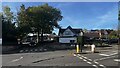
Entrance, Dr Challoners Grammar School for Boys
Image: © Bryn Holmes
Taken: 17 Oct 2023
0.05 miles
2
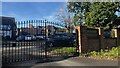
Entrance, Dr Challoners Grammar School for Boys
Image: © Bryn Holmes
Taken: 17 Oct 2023
0.05 miles
3
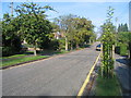
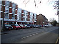
Longfield Drive, Amersham
A nice little street in the heart of commuter-land
Image: © Pip Rolls
Taken: 23 Aug 2005
0.07 miles
4
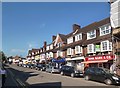
Hill Avenue, Amersham
Amersham on the Hill is quite different from Amersham Old Town, with its coaching and market origins, about 1km away in the Misbourne valley.
This is "Metroland", the extension of London suburban style development out into Bucks and Herts following the Metropolitan Railway which reached Amersham in 1892.
Image: © Des Blenkinsopp
Taken: 4 Sep 2013
0.08 miles
5
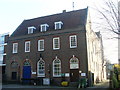
Amersham Telephone Exchange
Situated in Chesham Road, this building was the Post Office until the mid 1960s and housed the Manual TE until mid-1969. It has the code SMAM and serves 7,269 residential and 422 non-residential premises in Amersham, plus Chesham Bois, Coleshill and Winchmore Hill nearby. Two square BT warning notices can be seen on the front of the building whilst a yellow grit salt bin is below them. The numbering range of this TE is (01494) 43xxxx, 72xxxx, the (01494) referring to the High Wycombe group of TEs, and its postcode is HP6 5EZ.
Image: © David Hillas
Taken: 12 Nov 2008
0.09 miles
9
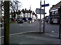
Oakfield Corner 2
Double mini-roundabout at Oakfield Corner, Amersham
Image: © Simon Hollett
Taken: 3 Apr 2014
0.12 miles