IMAGES TAKEN NEAR TO
Arrewig Lane, CHESHAM, HP5 2UA
Introduction
This page details the photographs taken nearby to Arrewig Lane, HP5 2UA by members of the Geograph project.
The Geograph project started in 2005 with the aim of publishing, organising and preserving representative images for every square kilometre of Great Britain, Ireland and the Isle of Man.

There are currently over 7.5m images from over14,400 individuals and you can help contribute to the project by visiting https://www.geograph.org.uk
Image Map
Images are licensed for reuse under creativecommons.org/licenses/by-sa/2.0
Notes
- Clicking on the map will re-center to the selected point.
- The higher the marker number, the further away the image location is from the centre of the postcode.
Image Listing (4 Images Found)
Images are licensed for reuse under creativecommons.org/licenses/by-sa/2.0
Image
Details
Distance
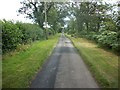
1
Road Closed! Arrewig Lane at Erriwig Farm
Road Closed! Arrewig Lane at Erriwig Farm the road was actually now open after UK Power Networks five day closure
Image: © Shaun Ferguson
Taken: 21 Feb 2020
0.00 miles
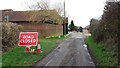
2
Scarecrow of Arrewig
A solitary scarecrow protects a large freshly-sprouting field next to Arrewig Farm. Arrewig is an old name for an earwig, so whether he frightens them off too I don't know !
Image: © Rob Farrow
Taken: 19 Apr 2006
0.05 miles
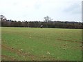
3
Arrewig Farm, Arrewig Lane
... or Errewig Farm if you believe the current OS:25000 map - and according to the 1940s map it was called Brown's Farm. This looks to be a fine old building, unfortunately this is about the best view you can get of it without invading their privacy. This was taken from the stile next to the farm.
Image: © Rob Farrow
Taken: 19 Apr 2006
0.05 miles