IMAGES TAKEN NEAR TO
Chartridge, CHESHAM, HP5 2TZ
Introduction
This page details the photographs taken nearby to HP5 2TZ by members of the Geograph project.
The Geograph project started in 2005 with the aim of publishing, organising and preserving representative images for every square kilometre of Great Britain, Ireland and the Isle of Man.

There are currently over 7.5m images from over14,400 individuals and you can help contribute to the project by visiting https://www.geograph.org.uk
Image Map
Images are licensed for reuse under creativecommons.org/licenses/by-sa/2.0
Notes
- Clicking on the map will re-center to the selected point.
- The higher the marker number, the further away the image location is from the centre of the postcode.
Image Listing (10 Images Found)
Images are licensed for reuse under creativecommons.org/licenses/by-sa/2.0
Image
Details
Distance

2
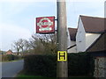
An Old Bus Stop near Chartridge
This old request bus stop is located outside Cherry Tree Farm, West of Chartridge, and dates from possibly the 1960s when green London Transport buses based at Amersham Garage,SU9697 refers, operated on routes 394/394A between Chesham and Great Missenden via Chartridge, Lee Common, Ballinger and South Heath. This route has since been replaced by route 177 operated by Redline and Red Rose. A traveline sticker can be seen on the stop below the LT roundel symbol. The fire hydrant sign below the stop shows the figures 100 and 5. The 100 refers to the size of the main that feeds that hydrant in millimetres whilst the 5 refers to the distance in metres from that plaque to where the hydrant is located. The postcode of this bus stop is HP5 2TZ.
Image: © David Hillas
Taken: 22 Mar 2012
0.01 miles
3
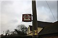
Old bus stop by Cherry Tree Farm, Chartridge
It's rusting but still in use. London Transport hasn't had buses out here for ages.
Image: © David Howard
Taken: 27 Jan 2019
0.01 miles
4

Old bus stop by Cherry Tree Farm, Chartridge
Image: © David Howard
Taken: 27 Jan 2019
0.02 miles

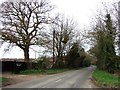
6
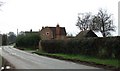
Cherry Tree Farm, Chartridge
This farm is opposite another farm (Chartridge End Farm) that mark the beginning of the village of Chartridge coming from a NW direction (travelling SE).
(I was a few yards OoS when I took this shot as the farm is almost on the 920 gridline.)
Image: © Rob Farrow
Taken: 19 Apr 2006
0.04 miles

8
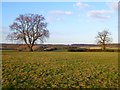
Farmland, Chartridge
Oaks viewed from the footpath to the north of Chartridge End Farm.
Image: © Andrew Smith
Taken: 15 Jan 2012
0.11 miles
9
Chalkfield Cottage and lane, near Chartridge
This cottage would seem to have been recently built as the OS:25000 map shows no building here at all. This lane leads to Swan Bottom.
Image: © Rob Farrow
Taken: 19 Apr 2006
0.17 miles
