IMAGES TAKEN NEAR TO
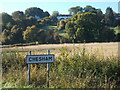
Buslins Lane, CHESHAM, HP5 2SN
Introduction
This page details the photographs taken nearby to Buslins Lane, HP5 2SN by members of the Geograph project.
The Geograph project started in 2005 with the aim of publishing, organising and preserving representative images for every square kilometre of Great Britain, Ireland and the Isle of Man.

There are currently over 7.5m images from over14,400 individuals and you can help contribute to the project by visiting https://www.geograph.org.uk
Image Map
Images are licensed for reuse under creativecommons.org/licenses/by-sa/2.0
Notes
- Clicking on the map will re-center to the selected point.
- The higher the marker number, the further away the image location is from the centre of the postcode.
Image Listing (6 Images Found)
Images are licensed for reuse under creativecommons.org/licenses/by-sa/2.0
Image
Details
Distance
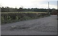
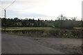
1
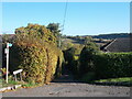
Sign for Buslins Lane
A public footpath sign indicates a public right of way down a steep hill leading on towards Captain's Wood and Asheridge Bottom.
Image: © Peter S
Taken: 9 Oct 2022
0.08 miles
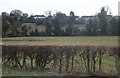
4
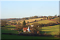
Countryside, Chesham
A view over a cottage on the Asheridge Road and a landscape of pastoral and arable farmland. The line of the road can be seen to the right of picture climbing onto the ridge.
Image: © Andrew Smith
Taken: 6 Dec 2008
0.16 miles