IMAGES TAKEN NEAR TO
Chartridge Lane, CHESHAM, HP5 2SL
Introduction
This page details the photographs taken nearby to Chartridge Lane, HP5 2SL by members of the Geograph project.
The Geograph project started in 2005 with the aim of publishing, organising and preserving representative images for every square kilometre of Great Britain, Ireland and the Isle of Man.

There are currently over 7.5m images from over14,400 individuals and you can help contribute to the project by visiting https://www.geograph.org.uk
Image Map
Images are licensed for reuse under creativecommons.org/licenses/by-sa/2.0
Notes
- Clicking on the map will re-center to the selected point.
- The higher the marker number, the further away the image location is from the centre of the postcode.
Image Listing (4 Images Found)
Images are licensed for reuse under creativecommons.org/licenses/by-sa/2.0
Image
Details
Distance
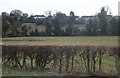
1
Sign for Buslins Lane
A public footpath sign indicates a public right of way down a steep hill leading on towards Captain's Wood and Asheridge Bottom.
Image: © Peter S
Taken: 9 Oct 2022
0.15 miles
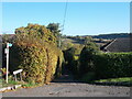
2
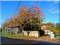
Seventeenth century barn and cottage, Chartridge
See http://www.britishlistedbuildings.co.uk/en-44626-barn-in-front-of-old-zacs-cottage-chartri and http://www.britishlistedbuildings.co.uk/en-44625-old-zacs-cottage-and-raymonds-cottage-cha for entry in British Listed Buildings
Image: © Bikeboy
Taken: 1 Nov 2014
0.16 miles
3
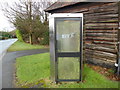
Former KX300 Telephone Kiosk in Chartridge (1)
Situated in Chartridge Lane HP5 2TF near Old Sax Lane, this telephone kiosk has a BT notice inside mentioning that it will shortly be removed due to lack of use. The BT Piper logo can be seen on the glass panel. Update: the telephone kiosk has since been removed from this location.
Image: © David Hillas
Taken: 4 Feb 2017
0.18 miles