IMAGES TAKEN NEAR TO
Pednor Road, CHESHAM, HP5 2JU
Introduction
This page details the photographs taken nearby to Pednor Road, HP5 2JU by members of the Geograph project.
The Geograph project started in 2005 with the aim of publishing, organising and preserving representative images for every square kilometre of Great Britain, Ireland and the Isle of Man.

There are currently over 7.5m images from over14,400 individuals and you can help contribute to the project by visiting https://www.geograph.org.uk
Image Map
Images are licensed for reuse under creativecommons.org/licenses/by-sa/2.0
Notes
- Clicking on the map will re-center to the selected point.
- The higher the marker number, the further away the image location is from the centre of the postcode.
Image Listing (64 Images Found)
Images are licensed for reuse under creativecommons.org/licenses/by-sa/2.0
Image
Details
Distance
1
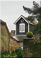
Dovecote at The Bury Farm, Chesham
A thoroughly wet day in March, with rooftiles glistening.
Image: © Stefan Czapski
Taken: 17 Mar 2013
0.00 miles
2
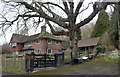
Warren Cottage on Pednor Road, Chesham
Image: © David Howard
Taken: 27 Jan 2019
0.03 miles
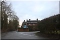
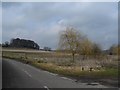
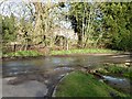
6
Flood at Pednor Road junction with Drydell Lane
If you look very closely you may be able to make out a pair of mallards - a duck and a drake. They had been swimming across the road a few moments earlier but unfortunately they'd made it to the drain on the far side of the road by the time I'd got my camera out. The flood was not particularly deep - maybe a foot at most.
Image: © Rob Farrow
Taken: 8 Mar 2014
0.06 miles
7
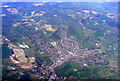
Chesham from the air
Viewed from a flight from Glasgow which was circling the town as it waited to land at Heathrow. See also Image
Image: © Thomas Nugent
Taken: 10 Apr 2011
0.09 miles
8
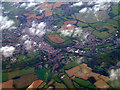
Chesham from the air
Looking up the B485 Missenden Road towards the town centre from a Heathrow bound flight from Glasgow. The cricket club and Chesham United FCs "The Meadow" ground can be seen.
Image: © Thomas Nugent
Taken: 9 Oct 2011
0.09 miles
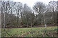
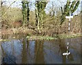
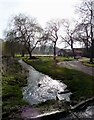
9
Water flowing under the road from Bury Pond
The water was gushing out of this conduit rather more forcefully than usual. It seems to be an overflow from Bury Pond on the other side of the road. The wetness of the road suggests that quite recently it had overflowed onto the road - and the road was flooded a few yards to the west (see Image])
Image: © Rob Farrow
Taken: 8 Mar 2014
0.09 miles
10
Drain at Pednormead End
I think that this drain at Pednormead End, Chesham has rather more water in it than is usual after weeks of heavy rain at the start of 2014 filled the aquifers. Thankfully this weekend the sun came out with a vengeance, and Spring seems to have arrived.
Image: © Rob Farrow
Taken: 8 Mar 2014
0.10 miles