IMAGES TAKEN NEAR TO
Chess Close, CHESHAM, HP5 1UU
Introduction
This page details the photographs taken nearby to Chess Close, HP5 1UU by members of the Geograph project.
The Geograph project started in 2005 with the aim of publishing, organising and preserving representative images for every square kilometre of Great Britain, Ireland and the Isle of Man.

There are currently over 7.5m images from over14,400 individuals and you can help contribute to the project by visiting https://www.geograph.org.uk
Image Map
Images are licensed for reuse under creativecommons.org/licenses/by-sa/2.0
Notes
- Clicking on the map will re-center to the selected point.
- The higher the marker number, the further away the image location is from the centre of the postcode.
Image Listing (9 Images Found)
Images are licensed for reuse under creativecommons.org/licenses/by-sa/2.0
Image
Details
Distance
2
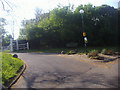
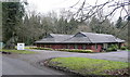
Parkfield Latimer
A private, very private and exclusive, housing estate. Even the history section of their website is by password only. This is the entrance. Although from the Chess Valley Way you get snatches of a view to the houses, this is the best view you get from the outside world. Snowdrops by the entrance, Spring is on the way.
Image: © Graham Horn
Taken: 5 Feb 2011
0.08 miles
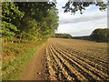
4
Chess Valley Walk
Chess Valley Walk beside Tooley's Croft
Image: © Shaun Ferguson
Taken: 18 Jul 2008
0.17 miles
5
Atex Media building
The sign tells us that it is the offices of Atex. Googling that company tells us that it is a media company but not any more. If you have arrived at this picture and want to know more about the company, sorry but I only took the picture.
Image: © Graham Horn
Taken: 5 Feb 2011
0.18 miles
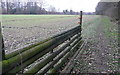
6
Chess Valley Walk beside Tooley's Croft
Image: © John Slater
Taken: 12 Oct 2017
0.20 miles
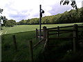
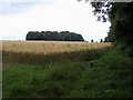
8
Footpath at Tooley's Croft
Tooley's Croft is the woodland to the right, and the footpath runs along the edge of that with arable land to the left. To our right is a path out of the private woods that seems to have been used by horses, and at its end, to our left, is this short section of wooden fence. I am speculating that the local hunt rides up the path and jumps this fence before going across the arable land. The wires have been put in place to stop that happening whilst the crop is growing. Any other ideas?
Image: © Graham Horn
Taken: 5 Feb 2011
0.24 miles
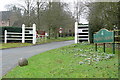
9
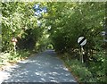
Church Lane, Latimer
Church Lane leads north out of Latimer towards Flaunden Bottom. This is just past the last house.
Image: © Marathon
Taken: 18 Sep 2019
0.25 miles