IMAGES TAKEN NEAR TO
Waterside, CHESHAM, HP5 1QF
Introduction
This page details the photographs taken nearby to Waterside, HP5 1QF by members of the Geograph project.
The Geograph project started in 2005 with the aim of publishing, organising and preserving representative images for every square kilometre of Great Britain, Ireland and the Isle of Man.

There are currently over 7.5m images from over14,400 individuals and you can help contribute to the project by visiting https://www.geograph.org.uk
Image Map
Images are licensed for reuse under creativecommons.org/licenses/by-sa/2.0
Notes
- Clicking on the map will re-center to the selected point.
- The higher the marker number, the further away the image location is from the centre of the postcode.
Image Listing (36 Images Found)
Images are licensed for reuse under creativecommons.org/licenses/by-sa/2.0
Image
Details
Distance
1
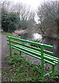
Rest by the Chess
This urban section of the Chess Valley Walk has some enjoyable stretches away from traffic by the river. There are frequent opportunities not to go any further. But we carried on because the seat was wet.
Image: © Graham Horn
Taken: 5 Feb 2011
0.03 miles
2
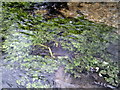
Cress in the Chess
The only working watercress beds today on the River Chess are at Moor Lane, Sarratt Bottom. The River Chess starts at Chesham and joins up with the River Colne at Rickmansworth,
Image: © Peter S
Taken: 28 Mar 2013
0.05 miles
3
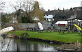
The Pheasant, quite pleasant
The view of the garden of the Pheasant pub from the south side of the River Chess. These boats are about as large as you would get on the river.
Image: © Graham Horn
Taken: 5 Feb 2011
0.06 miles
5
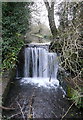
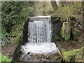
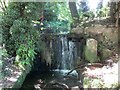
Weir on the River Chess
The weir is at the site of one of many former mills on the river. This is all there is to see now, as the mill house was demolished in the 1960s.
Image: © Graham Horn
Taken: 5 Feb 2011
0.10 miles
6
River Chess: Site of the former Cannon Mill
This weir and broken brickwork indicate the location of the former Cannon Mill, that is said to have been demolished in the 1960s. The flat body of water above the weir would have been the mill leat, and the water would have driven a mill wheel positioned in the brick recess below. There is a descriptive notice board nearby that describes it as Canon's Mill, but all the old Ordnance Survey mapping from 1878 onwards describes it as Cannon Mill, so the photographer has opted for the latter.
Incidentally the pink item above the weir that looks like a suspended animal carcase is in fact a children's play swing...
Image: © Nigel Cox
Taken: 13 Sep 2018
0.10 miles
7
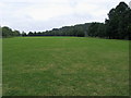
Chesham Moor
Chess Valley Walk at the North East edge of Chesham Moor
Image: © Shaun Ferguson
Taken: 18 Jul 2008
0.11 miles