IMAGES TAKEN NEAR TO
The Spinney, BERKHAMSTED, HP4 3YS
Introduction
This page details the photographs taken nearby to The Spinney, HP4 3YS by members of the Geograph project.
The Geograph project started in 2005 with the aim of publishing, organising and preserving representative images for every square kilometre of Great Britain, Ireland and the Isle of Man.

There are currently over 7.5m images from over14,400 individuals and you can help contribute to the project by visiting https://www.geograph.org.uk
Image Map
Images are licensed for reuse under creativecommons.org/licenses/by-sa/2.0
Notes
- Clicking on the map will re-center to the selected point.
- The higher the marker number, the further away the image location is from the centre of the postcode.
Image Listing (7 Images Found)
Images are licensed for reuse under creativecommons.org/licenses/by-sa/2.0
Image
Details
Distance
1
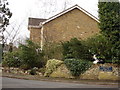
Oakwood, off Shooters Way, Berkhamsted
Image: © Jarvis Docherty
Taken: 21 Feb 2006
0.15 miles
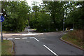
2
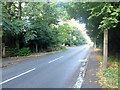
Shootersway, Berkhamsted
Shootersway runs parallel to the A41 on the western edge of the town.
Image: © John Allan
Taken: 12 Oct 2013
0.18 miles
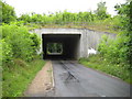
3
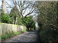
Denny Lane, Berkhamsted
Just behind the photographer (and in square Image) Denny Lane passes under the dual carriageway A41 Berkhamsted by-pass. So the scene is not as tranquil as the picture suggests!
Image: © David Purchase
Taken: 25 Mar 2011
0.22 miles
4
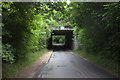
A41 bridge over Johns Lane looking northwards
Image: © Robert Eva
Taken: 24 Jun 2017
0.23 miles
5
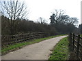
Beside the A41 Berkhamsted by-pass
This farm access track (also a Right of Way) was clearly realigned at the time that the bypass (in a cutting to the left) was constructed.
Despite the gazetteer info, all of this photo is - just - in Hertfordshire.
Image: © David Purchase
Taken: 25 Mar 2011
0.24 miles
7
Berkhamsted: Denny's Lane A41 bridge
This is the bridge that carries the A41 Berkhamsted bypass over Denny's Lane and is the one that Rob refers to in Image
Image: © Nigel Cox
Taken: 19 Jul 2009
0.24 miles