IMAGES TAKEN NEAR TO
BERKHAMSTED, HP4 3UQ
Introduction
This page details the photographs taken nearby to HP4 3UQ by members of the Geograph project.
The Geograph project started in 2005 with the aim of publishing, organising and preserving representative images for every square kilometre of Great Britain, Ireland and the Isle of Man.

There are currently over 7.5m images from over14,400 individuals and you can help contribute to the project by visiting https://www.geograph.org.uk
Image Map
Images are licensed for reuse under creativecommons.org/licenses/by-sa/2.0
Notes
- Clicking on the map will re-center to the selected point.
- The higher the marker number, the further away the image location is from the centre of the postcode.
Image Listing (12 Images Found)
Images are licensed for reuse under creativecommons.org/licenses/by-sa/2.0
Image
Details
Distance
1
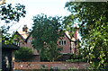
Marlin Chapel Farm
According to the notice board at the nearby ruined chapel, Marlin Chapel Farm stands on the site of a medieval moated house. The name "Marlin" is derived from "Magdalen", the original name of the chapel.
Image: © Tom Presland
Taken: 12 Sep 2010
0.02 miles
2
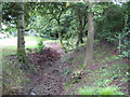
Northchurch: Marlin Chapel Farm moat
Marlin Chapel Farm occupies the site of an old moated farmhouse probably contemporary with Image The moat is now fragmented and this is one of the remnants, at the north-western corner, viewed from the public footpath.
Image: © Nigel Cox
Taken: 19 Jul 2009
0.04 miles
3
The Chapel of St Mary Magdalene
A ruined chapel close to Marlin Chapel Farm.
Image: © David Purchase
Taken: 25 Mar 2011
0.06 miles
4
The Chapel of St Mary Magdalene - descriptive plaque
Image: © David Purchase
Taken: 25 Mar 2011
0.06 miles
5
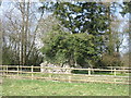
Northchurch: Ruined Chapel of St Mary Magdalene (Marlin Chapel)
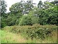
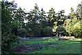
I think that these brambles conceal the ruined Chapel of St Mary Magdalene, the so-called Marlin Chapel. They are certainly in a regular rectangular pattern, with this being the long south side, and in the correct location according to the map.
The chapel was probably built in the 13th century, for Sir Lawrence de Broc, and Sir Richard de Berchamsted was a chaplain there. Many similar chapels were built at this time due to a rapid increase in the population, and St Mary Magdalene is one of as many as 43 that served this part of the Chilterns. This and other private manorial chapels were often not granted the right to carry out baptism, marriage or burial rites, as the larger parish churches were unwilling to lose the income received by carrying out these ceremonies. The remains of a medieval moated site, and its associated fishpond, lie a few yards east of the chapel. These may well have been built at the same time as the chapel.
It is unknown when the chapel fell into a ruinous state. However the 1884 edition of the Ordnance Survey's 6" to the mile mapping shows the chapel and describes it as "Remains of".
Image: © Nigel Cox
Taken: 19 Jul 2009
0.07 miles
6
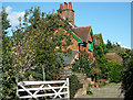
House near Marlin Chapel ruins
This house stands just in front of the chapel ruins.
Image: © Tom Presland
Taken: 12 Sep 2010
0.11 miles
7
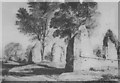
Chapel ruins
The ruined chapel of St Mary Magdalane. Due to the site being very overgrown it is not possible to get a photo of the site from the angle shown in the sketch on the information board Image] . This is the view from the opposite end.
Image: © Tom Presland
Taken: 12 Sep 2010
0.12 miles
8
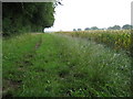
Northchurch: Bridleway to Marlin Chapel
This is a dog's view of the bridleway to Marlin Chapel, which is behind the photographer, looking back in the direction of Berkhamsted. The conical dark roof of Image can just be seen under the overhanging vegetation.
Image: © Nigel Cox
Taken: 19 Jul 2009
0.14 miles
9
Complete site of chapel ruins
The ruined chapel of St Mary Magdalane. Probably constructed for Sir Lawrence de Broc in the mid thirteenth century. The de Broc family were the owners of the large manor of Maudelyns: the medieval version of the word “Magdalane” and is also the derivation of the word “Marlin” used today.
Image: © Tom Presland
Taken: 12 Sep 2010
0.16 miles
10
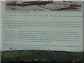
Sketch of ruined chapel
A detail from the notice board at the ruined chapel. The board has fallen down, and is currently resting against a tree almost out of view behind the fence that surrounds the site. This detail from the badly faded information board is the best I could manage. Photo of chapel site at: Image]
Image: © Tom Presland
Taken: 12 Sep 2010
0.16 miles