IMAGES TAKEN NEAR TO
Charles Street, BERKHAMSTED, HP4 3DG
Introduction
This page details the photographs taken nearby to Charles Street, HP4 3DG by members of the Geograph project.
The Geograph project started in 2005 with the aim of publishing, organising and preserving representative images for every square kilometre of Great Britain, Ireland and the Isle of Man.

There are currently over 7.5m images from over14,400 individuals and you can help contribute to the project by visiting https://www.geograph.org.uk
Image Map
Images are licensed for reuse under creativecommons.org/licenses/by-sa/2.0
Notes
- Clicking on the map will re-center to the selected point.
- The higher the marker number, the further away the image location is from the centre of the postcode.
Image Listing (129 Images Found)
Images are licensed for reuse under creativecommons.org/licenses/by-sa/2.0
Image
Details
Distance
1
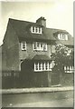
Ronhead, Montague Road, Berkhamsted in 1924
View taken by my late father George Baker. In 1924 the house possessed a front gate unlike in 2010 see http://www.geograph.org.uk/photo/2111152
Image: © George Baker
Taken: Unknown
0.07 miles
2
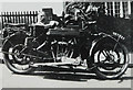
Royal Enfield motorbike
This view was taken by my father George Baker outside Image The motorbike, with the number plate NK 7927, was equipped with a sidecar.
Image: © George Baker
Taken: Unknown
0.07 miles
3
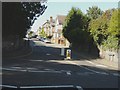
Charles Street, Berkhamsted
A similar view to that taken 44 years before see http://www.geograph.org.uk/photo/1757870
Image: © John Baker
Taken: 10 Oct 2010
0.07 miles
4

Ronhead, Montague Road, Berkhamsted
My paternal grandfather moved to Berkhamsted from Wallington, Surrey in the mid 1910s so that his two sons could attend Berkhamsted School. Ronhead is the left hand part of the semi in this view. The former owners of this house were a family called Leys, whose son (Colin McLaren) appears on this link http://www.bedfordregiment.org.uk/8thbn/8thbtnofficersdied.html
Image: © John Baker
Taken: 10 Oct 2010
0.08 miles
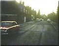
5
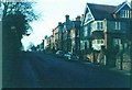
Charles Street, Berkhamsted in 1966
Taken near to the junction with Upper Kings Road.
Image: © John Baker
Taken: Unknown
0.08 miles
6
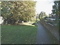
Passage linking North Road with Doctor's Commons Road, Berkhamsted
The area of grass to the left of the passage is where the air raid shelter referred to in 1970 see http://www.geograph.org.uk/photo/1764041 was situated. Its exact position was just to the left of the raised flowerbed. To the right of the passage, over the wall, two houses form part of Ilex Court
Image: © John Baker
Taken: 10 Oct 2010
0.09 miles
7
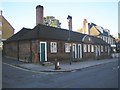
Berkhamsted: Sayer's Almshouses
Situated at the junction of Cowper Road with the High Street, these almshouses were originally built in 1684 to provide accommodation for six poor widows, as the result of a gift of £1,000 left in trust by John Sayer, chief cook to King Charles II. The inscription on the tablet in the centre reads:
THE
GUIFT OF
JOHN SAYER
ESQ.
1684.
Image: © Nigel Cox
Taken: 21 Oct 2007
0.09 miles
8
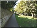
Passage linking North Road with Doctor's Commons Road, Berkhamsted
Looking in the direction of North Road. The vehicle is parked in Montague Road as the passage skirts this road before continuing to North Road. There was an air raid shelter just to the right of the raised flower bed see http://www.geograph.org.uk/photo/2109940
Image: © John Baker
Taken: 10 Oct 2010
0.10 miles
9
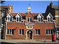
Berkhamsted: The former Bourne School
A school was founded on this site in 1737 through an endowment of £8,000 made by Thomas Bourne, a rich London merchant. The Bourne School was to cater for twenty boys and ten girls. The present building was erected in 1854, largely at the expense of General John Finch of Berkhamsted Place, another local benefactor. The three coats of arms over the front door are those of Berkhamsted Town, Thomas Bourne and John Finch. In 1888 the Bourne School became the first home of Berkhamsted School for Girls. Today, as the sign suggests, the building is used by the Britannia Building Society.
Image: © Nigel Cox
Taken: 21 Oct 2007
0.10 miles
10
Montague Road, Berkhamsted in 1966
Possibly taken into the sun but submitted to show another view of the house seen at the top of the road Image from another angle.
Image: © John Baker
Taken: Unknown
0.10 miles