IMAGES TAKEN NEAR TO
Kings Road, BERKHAMSTED, HP4 3BD
Introduction
This page details the photographs taken nearby to Kings Road, HP4 3BD by members of the Geograph project.
The Geograph project started in 2005 with the aim of publishing, organising and preserving representative images for every square kilometre of Great Britain, Ireland and the Isle of Man.

There are currently over 7.5m images from over14,400 individuals and you can help contribute to the project by visiting https://www.geograph.org.uk
Image Map
Images are licensed for reuse under creativecommons.org/licenses/by-sa/2.0
Notes
- Clicking on the map will re-center to the selected point.
- The higher the marker number, the further away the image location is from the centre of the postcode.
Image Listing (170 Images Found)
Images are licensed for reuse under creativecommons.org/licenses/by-sa/2.0
Image
Details
Distance
1
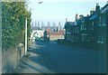
Upper Kings Road, Berkhamsted in 1966
Taken from its junction with Charles Street looking in the direction of the High Street.
Image: © John Baker
Taken: Unknown
0.00 miles
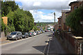
3
Upper Kings Road, Berkhamsted
Not taken from quite the same angle as my view of 1966 see http://www.geograph.org.uk/photo/1757902 but the difference is the lack of parked cars in the earlier view. Kings Road was formerly called Bridewell Lane (and before that as Cocks Lane) named after a prison (or bridewell) that stood on the easterly corner the present Upper Kings Road at its junction with the High Street.
Image: © John Baker
Taken: 10 Oct 2010
0.02 miles
4
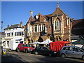
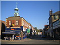
Berkhamsted: The Town Hall
Berkhamsted's medieval market house stood on this site until it was burnt down in 1854. This is the replacement building, constructed in 1859 to the design of Edward Buckton Lamb. It was originally known as the Market House and Town Hall. The ground floor is now in use as a brasserie, although the upper floor is still used as a community amenity.
Berkhamsted's farmers' market, held on the third Sunday of each month, is in full swing outside.
Image: © Nigel Cox
Taken: 21 Oct 2007
0.04 miles
5
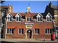
Berkhamsted: The de Lisle clock
Viewed looking down the Lower Kings Road from the High Street, the de Lisle clock and cupola is on the building to the left, Kings Chambers. This is the Town Clock and Berkhamsted Town Council appear to have a responsibility to maintain it. The inscription on the face of the clock reads:
DE LISLE & SONS
JEWELLERS
Image: © Nigel Cox
Taken: 21 Oct 2007
0.04 miles
6
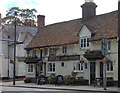
Berkhamsted: The former Bourne School
A school was founded on this site in 1737 through an endowment of £8,000 made by Thomas Bourne, a rich London merchant. The Bourne School was to cater for twenty boys and ten girls. The present building was erected in 1854, largely at the expense of General John Finch of Berkhamsted Place, another local benefactor. The three coats of arms over the front door are those of Berkhamsted Town, Thomas Bourne and John Finch. In 1888 the Bourne School became the first home of Berkhamsted School for Girls. Today, as the sign suggests, the building is used by the Britannia Building Society.
Image: © Nigel Cox
Taken: 21 Oct 2007
0.05 miles
8
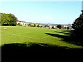
Butts Meadow, Berkhamsted
The field derives its name from the time when longbowmen practised at the butts. It was given to the town by Mrs Lionel Lucas.
Image: © John Baker
Taken: 10 Oct 2010
0.06 miles
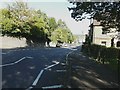
10
Kings Road nearing High Street, Berkhamsted
Image: © Colin Pyle
Taken: 29 Feb 2016
0.06 miles