IMAGES TAKEN NEAR TO
Stanier Rise, BERKHAMSTED, HP4 1SD
Introduction
This page details the photographs taken nearby to Stanier Rise, HP4 1SD by members of the Geograph project.
The Geograph project started in 2005 with the aim of publishing, organising and preserving representative images for every square kilometre of Great Britain, Ireland and the Isle of Man.

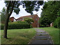
There are currently over 7.5m images from over14,400 individuals and you can help contribute to the project by visiting https://www.geograph.org.uk
Image Map
Images are licensed for reuse under creativecommons.org/licenses/by-sa/2.0
Notes
- Clicking on the map will re-center to the selected point.
- The higher the marker number, the further away the image location is from the centre of the postcode.
Image Listing (16 Images Found)
Images are licensed for reuse under creativecommons.org/licenses/by-sa/2.0
Image
Details
Distance
1
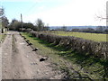
Northchurch Common
Lane at the edge of Northchurch Common. The view looks South East, Berkhamsted lies at the bottom of the slope to the right, and covers the hill in the distance.
Image: © Chris Cole
Taken: 25 Feb 2006
0.05 miles
2
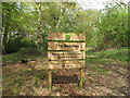
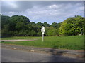
Sign for woodland "The Beeches"
Sign from Dacorum Borough Council.
Image: © David Hawgood
Taken: 28 Apr 2010
0.07 miles
3
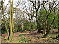
Woodland "The Beeches", Berkhamsted
Owned by Dacorum Borough Council - see Image
Image: © David Hawgood
Taken: 28 Apr 2010
0.07 miles
4
Northchurch Common
The lane runs NW-SE on the edge of Northchurch Common. There are secluded houses all along one side, and views across fields down to Berkhamsted and Northchurch to the left of the picture.
Image: © Chris Cole
Taken: 25 Feb 2006
0.15 miles
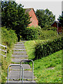
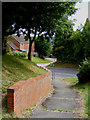
5
Footpath from St Katherines Way to Northchurch House
This path starts from the junction of St Katherines Way and Haynes Mead and climbs through Chiltern Park Estate to join other paths leading to Northchurch House and Northchurch Common.
Image: © David Sands
Taken: 16 Jul 2009
0.17 miles
6
Footpath from St Katherines Way to Northchurch House
An alternative start to the footpath from the junction of St Katherines Way and Mortain Drive
Image: © David Sands
Taken: 16 Jul 2009
0.17 miles
7
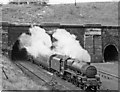
Northchurch Tunnel, south portals with Up express
View northward, on the West Coast Main line between Berkhamsted and Tring, with an Up express emerging from the Fast lines double-bore, headed by LMS 'Jubilee' 6P 4-6-0 No. 45674 'Duncan'; the two single bores for the Slow lines are on the right.
Image: © Ben Brooksbank
Taken: 14 Oct 1950
0.18 miles
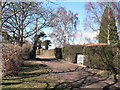
8
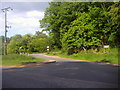
Entrance to Northchurch Common, New Road
Image: © David Howard
Taken: 19 May 2011
0.18 miles
9
Entrance to Northchurch Common, New Road
Image: © David Howard
Taken: 19 May 2011
0.18 miles
10
Footpath from St Katherines Way to Northchurch House
Looking back to the start of the path near the junction of St Katherines Way and Haynes Mead.
Image: © David Sands
Taken: 16 Jul 2009
0.20 miles