IMAGES TAKEN NEAR TO
Ringshall Road, BERKHAMSTED, HP4 1RN
Introduction
This page details the photographs taken nearby to Ringshall Road, HP4 1RN by members of the Geograph project.
The Geograph project started in 2005 with the aim of publishing, organising and preserving representative images for every square kilometre of Great Britain, Ireland and the Isle of Man.

There are currently over 7.5m images from over14,400 individuals and you can help contribute to the project by visiting https://www.geograph.org.uk
Image Map
Images are licensed for reuse under creativecommons.org/licenses/by-sa/2.0
Notes
- Clicking on the map will re-center to the selected point.
- The higher the marker number, the further away the image location is from the centre of the postcode.
Image Listing (6 Images Found)
Images are licensed for reuse under creativecommons.org/licenses/by-sa/2.0
Image
Details
Distance
1
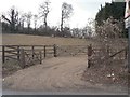
Paddock by Ringshall Road
Viewed to the West from Ringshall Road, which leads from Ringshall northwards to Dagnall.
Image: © Chris Cole
Taken: 6 Mar 2006
0.05 miles
2
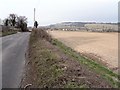
Ringshall Road
View down Ringshall Road towards Dagnall, which can be seen in the distance.
Image: © Chris Cole
Taken: 6 Mar 2006
0.08 miles
3
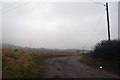
Aylesbury Vale : Track
A track heading off from Ringshall Road towards Cha Reetaa.
Image: © Lewis Clarke
Taken: 24 Mar 2018
0.09 miles
4
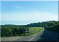
B4506 Ringshall Road near Applewood Cottage
Image: © Colin Pyle
Taken: 13 May 2022
0.10 miles
5
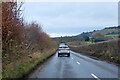
B4506 Ringshall Road
Towards Dunstable.
Image: © Robin Webster
Taken: 5 Dec 2021
0.17 miles
6
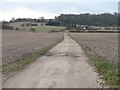
Track to Well Farm
The track leaves Main Road South, and heads South East to Well Farm, which can be seen in the centre-right of the picture. Oakley Wood appears in the background.
Image: © Chris Cole
Taken: 6 Mar 2006
0.24 miles