IMAGES TAKEN NEAR TO
Eddy Street, BERKHAMSTED, HP4 1DQ
Introduction
This page details the photographs taken nearby to Eddy Street, HP4 1DQ by members of the Geograph project.
The Geograph project started in 2005 with the aim of publishing, organising and preserving representative images for every square kilometre of Great Britain, Ireland and the Isle of Man.

There are currently over 7.5m images from over14,400 individuals and you can help contribute to the project by visiting https://www.geograph.org.uk
Image Map
Images are licensed for reuse under creativecommons.org/licenses/by-sa/2.0
Notes
- Clicking on the map will re-center to the selected point.
- The higher the marker number, the further away the image location is from the centre of the postcode.
Image Listing (130 Images Found)
Images are licensed for reuse under creativecommons.org/licenses/by-sa/2.0
Image
Details
Distance
1
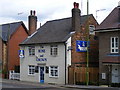
The Rose and Crown, Berkhamsted High Street
Image: © David Sands
Taken: 9 Jul 2009
0.02 miles
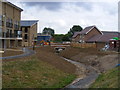
2
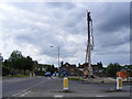
Birth of a housing estate
Starting with this great big drill, a vast housing development will be constructed (on a site between Berkhamsted High Street, Stag Lane and the Grand Union Canal).
Image: © David Sands
Taken: 17 Aug 2007
0.03 miles
3

The Locks development at Stag Lane, Berkhamsted
Newly built cottages in Sheldon Way
Image: © David Sands
Taken: 8 Aug 2009
0.03 miles
4
Blackberry harvest in Berkhamsted High Street
Image: © David Sands
Taken: 15 Aug 2009
0.04 miles
5
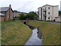
The Locks development at Stag Lane, Berkhamsted
The new course of the River Bulbourne is a feature of the development, seen here looking upstream towards Billet Lane.
Image: © David Sands
Taken: 16 Jul 2009
0.05 miles
6
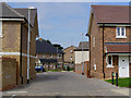
The Locks development at Stag Lane, Berkhamsted
Nash Close, one of the completed roads in the new estate.
Image: © David Sands
Taken: 8 Aug 2009
0.05 miles
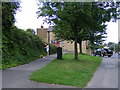
7
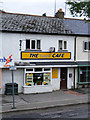
Gossoms End, Berkhamsted
The Yeovil café at Gossoms End. The parking restrictions allow exactly one hour for a relaxed meal.
Image: © David Sands
Taken: 13 Jul 2009
0.05 miles
8
The Locks development at Stag Lane, Berkhamsted
The course of the River Bulbourne has been diverted through the site to make an attractive landscape feature
Image: © David Sands
Taken: 16 Jul 2009
0.05 miles
9
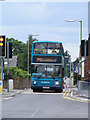
Stag Lane, Berkhamsted
A double-decker on the 500 service to Watford pulls away from Stag Lane traffic lights in Berkhamsted High Street.
Image: © David Sands
Taken: 8 Aug 2009
0.06 miles
10

Gossoms End, Berkhamsted
Elevated pavement serving recently built dwellings at Gossoms End
Image: © David Sands
Taken: 13 Jul 2009
0.06 miles