IMAGES TAKEN NEAR TO
Whiteleaf Road, HEMEL HEMPSTEAD, HP3 9PH
Introduction
This page details the photographs taken nearby to Whiteleaf Road, HP3 9PH by members of the Geograph project.
The Geograph project started in 2005 with the aim of publishing, organising and preserving representative images for every square kilometre of Great Britain, Ireland and the Isle of Man.

There are currently over 7.5m images from over14,400 individuals and you can help contribute to the project by visiting https://www.geograph.org.uk
Image Map
Images are licensed for reuse under creativecommons.org/licenses/by-sa/2.0
Notes
- Clicking on the map will re-center to the selected point.
- The higher the marker number, the further away the image location is from the centre of the postcode.
Image Listing (70 Images Found)
Images are licensed for reuse under creativecommons.org/licenses/by-sa/2.0
Image
Details
Distance
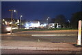
1
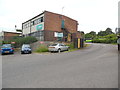
Entrance to Arriva Bus Depot, Hemel Hempstead
Situated in Whiteleaf Road HP3 9PH, this bus depot opened in July 1995 replacing the former bus depot at nearby Two Waters, the latter having since been demolished and replaced by the A414 link road. Approximately fifty vehicles are based here running local town services plus those to Aylesbury, Rickmansworth and Watford. It is also responsible for the Green Line 758 service to Central London. A Green Line coach can just be seen parked in the depot yard.
Image: © David Hillas
Taken: 8 Jul 2016
0.03 miles
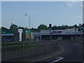
2
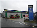
London Road Trade Centre
ATS Euromaster. A nationwide tyre retailer and service provider.
Image: © Burgess Von Thunen
Taken: 27 Nov 2012
0.04 miles
4
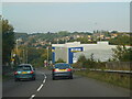
A414 road coming down from the A41, Hemel Hempstead
Image: © Bryn Holmes
Taken: 11 Oct 2015
0.08 miles
5
The A4251 from Two Waters Way junction
Image: © David Howard
Taken: 19 May 2011
0.09 miles
6
Nickey Line remains at London Road Boxmoor A4251, Hemel Hempstead
This is the section south of Hemel town centre that tried to make a connection to the LNWR (London Euston to Birmingham line) at Boxmoor but failed. Midland Railway branch from Harpenden. Old retaining wall remains in blue brick are visible here, where the road underbridge straddled the old A41 behind me.
It's not a part of the Nickey Trail cycle path from Harpenden; this is an isolated piece of embankment south of the site of Heath Park Halt which was the furthest station of the branch line town station quite close to old and redone Marlowes, and immediately north of the old Hemel to Berkhamsted road just by the present day Aldi. The other end, a hundred metres or so away from here, is isolated by the River Bulbourne. Historic maps 1877 - 1960 on the National Library of Scotland database show the line well; the last map shows the 'Magic Roundabout' superimposed on the line route where there was a viaduct over Marlowes.
Land administered by the Boxmoor Trust.
Image: © Simon Marshall
Taken: 2 Apr 2023
0.09 miles
7
Two Waters Road, Hemel Hempstead
Looking towards London Road.
Image: © David Howard
Taken: 26 Nov 2022
0.09 miles

10
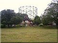
Two Waters Gas works
Gas Holder at Two Waters Gas works, Hemel Hempstead.
Image: © Graham Hale
Taken: 10 Aug 2010
0.11 miles