IMAGES TAKEN NEAR TO
Corner Hall Avenue, HEMEL HEMPSTEAD, HP3 9EE
Introduction
This page details the photographs taken nearby to Corner Hall Avenue, HP3 9EE by members of the Geograph project.
The Geograph project started in 2005 with the aim of publishing, organising and preserving representative images for every square kilometre of Great Britain, Ireland and the Isle of Man.

There are currently over 7.5m images from over14,400 individuals and you can help contribute to the project by visiting https://www.geograph.org.uk
Image Map
Images are licensed for reuse under creativecommons.org/licenses/by-sa/2.0
Notes
- Clicking on the map will re-center to the selected point.
- The higher the marker number, the further away the image location is from the centre of the postcode.
Image Listing (91 Images Found)
Images are licensed for reuse under creativecommons.org/licenses/by-sa/2.0
Image
Details
Distance
1
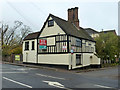
Three Gables, Hemel Hempstead
A grade II*(star) listed building from around 1600. Currently with 'Character office suites' to let.
Image: © Robin Webster
Taken: 16 Nov 2014
0.06 miles
3
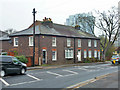
64 - 68 (evens) Lawn Lane, Hemel Hempstead
Three houses, all different in size and arrangement, with areas and basements. Some way behind was a wharf area (now filled in) on the Grand Union Canal - it may be that these were associated.
Image: © Robin Webster
Taken: 16 Nov 2014
0.09 miles
4
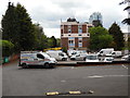
Hemel Hempstead Telephone Exchange (2)
Taken from Lamsey Road, this photo shows the East side of this large TE with several BT Openreach vehicles parked in front of it. The tall KD Tower, which has apartments, can be seen in the distance behind the TE. It replaced the Kodak Tower somewhile ago. The postcode of this TE is HP2 4XD.
Image: © David Hillas
Taken: 9 May 2015
0.10 miles
5
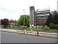
Hemel Hempstead Telephone Exchange (1)
Situated on the A414 St Albans Road near the town centre, this TE replaced the former Manual TE, known as Boxmoor, during the mid-1960s. Besides Hemel Hempstead, this TE also serves Great Gaddesden and Water End nearby. Mobile phone aerials can be seen on the roof of this building.
Image: © David Hillas
Taken: 9 May 2015
0.11 miles
6
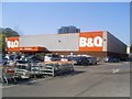
B&Q at Boxmoor wharf, Grand Union Canal, Hemel Hempstead
This site was the goods wharf on the Grand Junction Canal serving the Hemel Hempstead area. It later became a depot for Roses Lime Juice and today hosts a B&Q DIY supermarket.
The former Kodak Tower, now known as the Image apartment building can be seen beyond the store.
Image: © Graham Hale
Taken: 17 Apr 2010
0.12 miles
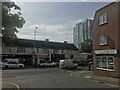
7
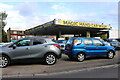
Magic Hand Car Wash on Two Waters Road, Hemel Hempstead
Image: © David Howard
Taken: 4 Sep 2022
0.13 miles
8
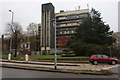
Office block on St Albans Road, Hemel Hempstead
Image: © David Howard
Taken: 23 Nov 2019
0.13 miles
9
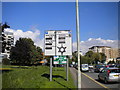
Magic roundabout signs, Hemel Hempstead
Two of the signs on the southern approach to the Plough Roundabout, known colloquially as the Magic Roundabout, which is actually six mini roundabouts that form a likeness of a large, two way roundabout. From a distance, the roundabout looks uncannily like the Star of David on the sign in the foreground.
Image: © Richard Vince
Taken: 20 Sep 2015
0.13 miles
10
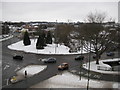
Hemel Hempstead: The Magic Roundabout
Hemel's Magic Roundabout was constructed in 1973, a year after its counterpart in Swindon. It is formally known as The Plough Roundabout or Moor End Roundabout. Despite their reputation these roundabouts work well and it is doubtful if any driver using them regularly would think twice about them. The River Gade flows through the middle. This is an accidental retake from the same viewpoint of Giles' Image The one major change that seems to have taken place is the reconfiguration of the junction arrangements with the road bottom right.
Image: © Nigel Cox
Taken: 10 Jan 2010
0.14 miles