IMAGES TAKEN NEAR TO
Harthall Lane, HEMEL HEMPSTEAD, HP3 8SD
Introduction
This page details the photographs taken nearby to Harthall Lane, HP3 8SD by members of the Geograph project.
The Geograph project started in 2005 with the aim of publishing, organising and preserving representative images for every square kilometre of Great Britain, Ireland and the Isle of Man.

There are currently over 7.5m images from over14,400 individuals and you can help contribute to the project by visiting https://www.geograph.org.uk
Image Map
Images are licensed for reuse under creativecommons.org/licenses/by-sa/2.0
Notes
- Clicking on the map will re-center to the selected point.
- The higher the marker number, the further away the image location is from the centre of the postcode.
Image Listing (7 Images Found)
Images are licensed for reuse under creativecommons.org/licenses/by-sa/2.0
Image
Details
Distance
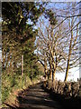
4
Kings Langley: Harthall Lane
Viewed looking eastwards towards Pimlico.
Image: © Nigel Cox
Taken: 25 Feb 2006
0.15 miles
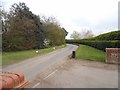
5
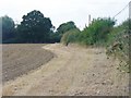
Harthall Lane - Field Edge
Wide margin left beside a newly harrowed field near Kings Langley.
Image: © Colin Smith
Taken: 28 Sep 2014
0.18 miles
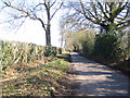
6
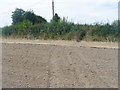
Indistinct Footpath
Path over a newly ploughed and harrowed field near Kings Langley. Its alignment is clear and will become more so as ramblers use it through the autumn and winter months.
Image: © Colin Smith
Taken: 28 Sep 2014
0.23 miles
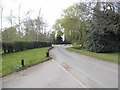
7
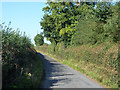
Harthall Lane
Heading towards Kings Langley.
Image: © Robin Webster
Taken: 6 Sep 2015
0.25 miles