IMAGES TAKEN NEAR TO
Water Lane, HEMEL HEMPSTEAD, HP3 0NA
Introduction
This page details the photographs taken nearby to Water Lane, HP3 0NA by members of the Geograph project.
The Geograph project started in 2005 with the aim of publishing, organising and preserving representative images for every square kilometre of Great Britain, Ireland and the Isle of Man.

There are currently over 7.5m images from over14,400 individuals and you can help contribute to the project by visiting https://www.geograph.org.uk
Image Map
Images are licensed for reuse under creativecommons.org/licenses/by-sa/2.0
Notes
- Clicking on the map will re-center to the selected point.
- The higher the marker number, the further away the image location is from the centre of the postcode.
Image Listing (4 Images Found)
Images are licensed for reuse under creativecommons.org/licenses/by-sa/2.0
Image
Details
Distance
1
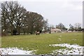
Horses grazing near Rose Farm
Looking north-east from Middle Lane towards Rose Farm.
Image: © Simon Mortimer
Taken: 27 Mar 2013
0.10 miles
2
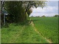
Chiltern Way
Chiltern Way where the path from Water Lane to Chipperfield Lane crosses
Image: © Shaun Ferguson
Taken: 7 May 2010
0.19 miles
4
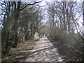
Bovingdon: Holly Hedges Lane
Aptly named and looking south eastwards towards Belsize.
Image: © Nigel Cox
Taken: 5 Mar 2006
0.25 miles