IMAGES TAKEN NEAR TO
Glamis Close, HEMEL HEMPSTEAD, HP2 7QB
Introduction
This page details the photographs taken nearby to Glamis Close, HP2 7QB by members of the Geograph project.
The Geograph project started in 2005 with the aim of publishing, organising and preserving representative images for every square kilometre of Great Britain, Ireland and the Isle of Man.

There are currently over 7.5m images from over14,400 individuals and you can help contribute to the project by visiting https://www.geograph.org.uk
Image Map
Images are licensed for reuse under creativecommons.org/licenses/by-sa/2.0
Notes
- Clicking on the map will re-center to the selected point.
- The higher the marker number, the further away the image location is from the centre of the postcode.
Image Listing (2 Images Found)
Images are licensed for reuse under creativecommons.org/licenses/by-sa/2.0
Image
Details
Distance
1
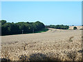
Wheat field north of Hemel Hempstead
The apparent wood on the left is just a belt along a bridleway, behind which is hidden the northern extremity of the Hemel Hempstead built-up area.
Image: © Robin Webster
Taken: 6 Sep 2015
0.18 miles
2
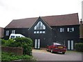
Houses in Cupid Green Lane
Being very close to the edge of the development they were intended to look like barn conversions.
Image: © Jack Hill
Taken: 20 Aug 2005
0.25 miles