IMAGES TAKEN NEAR TO
Lilly Lane, HEMEL HEMPSTEAD, HP2 7HR
Introduction
This page details the photographs taken nearby to Lilly Lane, HP2 7HR by members of the Geograph project.
The Geograph project started in 2005 with the aim of publishing, organising and preserving representative images for every square kilometre of Great Britain, Ireland and the Isle of Man.

There are currently over 7.5m images from over14,400 individuals and you can help contribute to the project by visiting https://www.geograph.org.uk
Image Map
Images are licensed for reuse under creativecommons.org/licenses/by-sa/2.0
Notes
- Clicking on the map will re-center to the selected point.
- The higher the marker number, the further away the image location is from the centre of the postcode.
Image Listing (4 Images Found)
Images are licensed for reuse under creativecommons.org/licenses/by-sa/2.0
Image
Details
Distance
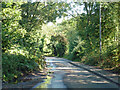
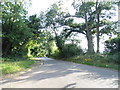
1
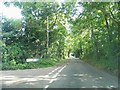
Cherry Tree Lane, Cupid Green
At the junction of Lilly Lane
Image: © David Howard
Taken: 5 Sep 2013
0.14 miles
3
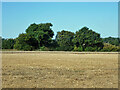
Field west of Cherry Tree Lane
Partly mown.
Image: © Robin Webster
Taken: 6 Sep 2015
0.17 miles