IMAGES TAKEN NEAR TO
Maxted Road, HEMEL HEMPSTEAD, HP2 7HD
Introduction
This page details the photographs taken nearby to Maxted Road, HP2 7HD by members of the Geograph project.
The Geograph project started in 2005 with the aim of publishing, organising and preserving representative images for every square kilometre of Great Britain, Ireland and the Isle of Man.

There are currently over 7.5m images from over14,400 individuals and you can help contribute to the project by visiting https://www.geograph.org.uk
Image Map
Images are licensed for reuse under creativecommons.org/licenses/by-sa/2.0
Notes
- Clicking on the map will re-center to the selected point.
- The higher the marker number, the further away the image location is from the centre of the postcode.
Image Listing (6 Images Found)
Images are licensed for reuse under creativecommons.org/licenses/by-sa/2.0
Image
Details
Distance
1
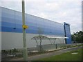
Mistral 260 in Maylands
Can't decide what the shelter in the foreground is intended to do. The bulk behind is a vast distribution warehouse built in 2005 by logistics developers, Gazeley.
Image: © Jack Hill
Taken: 20 Aug 2005
0.16 miles
2
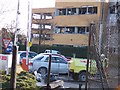
3-Com and Kodak office: Buncefield
Damage typical to nearby offices.
Image: © Denis Kelly
Taken: 17 Dec 2005
0.18 miles
3
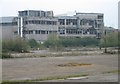
Buncefield: Three years and four months on (2)
Although most of the industrial buildings damaged during the explosion have been, or are, being repaired, and the most severely damaged ones have been demolished, some remain more or less as they were immediately after the explosion. This is the rear of one such building, viewed from Buncefield Lane, and the direction of the source of the explosion, across the car park of the now demolished Northgate Information Solutions building.
Image: © Nigel Cox
Taken: 12 Apr 2009
0.21 miles
4
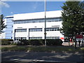
Post office depot on Maylands Avenue, Hemel Hempstead
Image: © David Howard
Taken: 13 Jul 2017
0.21 miles
5
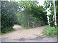
Entrance to Cherry Tree Farm
The house is visible from Punchbowl Lane located amongst a grove of pine trees.
Image: © Jack Hill
Taken: 20 Aug 2005
0.22 miles
6
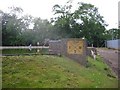
Emergency Water supply point
This is located close to the oil filling terminal.
Note the capacity of 1,000,000 litres.
Image: © Jack Hill
Taken: 20 Aug 2005
0.22 miles