IMAGES TAKEN NEAR TO
Mark Road, HEMEL HEMPSTEAD, HP2 7DN
Introduction
This page details the photographs taken nearby to Mark Road, HP2 7DN by members of the Geograph project.
The Geograph project started in 2005 with the aim of publishing, organising and preserving representative images for every square kilometre of Great Britain, Ireland and the Isle of Man.

There are currently over 7.5m images from over14,400 individuals and you can help contribute to the project by visiting https://www.geograph.org.uk
Image Map (Loading...)


Getting Data...Please wait
Leaflet Map data © OpenStreetMap
Images are licensed for reuse under creativecommons.org/licenses/by-sa/2.0
Notes
- Clicking on the map will re-center to the selected point.
- The higher the marker number, the further away the image location is from the centre of the postcode.
Image Listing (16 Images Found)
Images are licensed for reuse under creativecommons.org/licenses/by-sa/2.0
Image
Details
Distance
3
Water Tower in High Street, Hemel Hempstead
This old structure contrasts with the new business unit in Photo 1
Image: © Jack Hill
Taken: 25 Aug 2005
0.14 miles
5
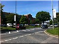
Maylands Avenue at the intersection with Eaton Road
Image: © Darrin Antrobus
Taken: 5 Jun 2013
0.16 miles
6
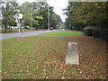
Hemel Hempstead: High Street Green Triangulation Pillar
Now rather incongruously sited in the grass verge on the east side of High Street Green and surrounded by houses and trees, this survey triangulation pillar, which was originally surveyed in 1948, served its purpose before and during the development of Hemel Hempstead after the Second World War. Its published co-ordinates are Easting 507237.625, Northing 208316.031, but these have not been realised through the current ETRS89 (European Terrestrial Reference System 1989) and OSTN02 transformation parameters, so the OS would not consider them now to be the true co-ordinates. The height of the reference mark on the flush bracket on the side of the pillar is 148.556 metres above sea level.
Image: © Nigel Cox
Taken: 14 Oct 2007
0.17 miles
7
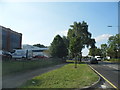
Maylands Avenue, Cupid Green
In the middle of the industrial estate
Image: © David Howard
Taken: 5 Sep 2013
0.17 miles
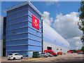
8
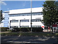
Post office depot on Maylands Avenue, Hemel Hempstead
Image: © David Howard
Taken: 13 Jul 2017
0.17 miles
10
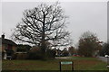
High Street Green at the corner of Highfield Lane
Image: © David Howard
Taken: 23 Nov 2019
0.17 miles