IMAGES TAKEN NEAR TO
Thame Road, PRINCES RISBOROUGH, HP27 9RY
Introduction
This page details the photographs taken nearby to Thame Road, HP27 9RY by members of the Geograph project.
The Geograph project started in 2005 with the aim of publishing, organising and preserving representative images for every square kilometre of Great Britain, Ireland and the Isle of Man.

There are currently over 7.5m images from over14,400 individuals and you can help contribute to the project by visiting https://www.geograph.org.uk
Image Map
Images are licensed for reuse under creativecommons.org/licenses/by-sa/2.0
Notes
- Clicking on the map will re-center to the selected point.
- The higher the marker number, the further away the image location is from the centre of the postcode.
Image Listing (15 Images Found)
Images are licensed for reuse under creativecommons.org/licenses/by-sa/2.0
Image
Details
Distance
1
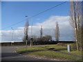
Roundabout on Longwick Road
At the junction of Lower Icknield Way
Image: © David Howard
Taken: 20 Mar 2016
0.07 miles
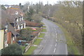
2
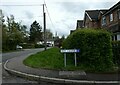
Looking from Ivy Close into Chestnut Way
Image: © Basher Eyre
Taken: 23 May 2021
0.12 miles
3
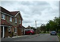
Looking from Bell Crescent into Chestnut Way
Image: © Basher Eyre
Taken: 23 May 2021
0.14 miles
6
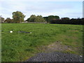
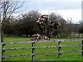
Field on edge of Longwick
Field off Thame Road on the edge of Longwick
Image: © Shaun Ferguson
Taken: 3 Oct 2008
0.16 miles
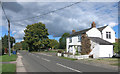
7
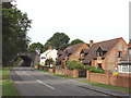
Houses and railway bridge, on B4009 at Longwick
The railway comes from High Wycombe and goes on to Bicester
Image: © David Hawgood
Taken: 4 Aug 2005
0.16 miles
8
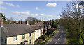
Lower Icknield Way
Looking north east along the B4009 Lower Icknield Way from the railway bridge.
Image: © David P Howard
Taken: 13 Apr 2014
0.18 miles
10
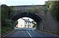
Railway bridge on Lower Icknield Way, Longwick
Image: © David Howard
Taken: 27 Sep 2022
0.20 miles