IMAGES TAKEN NEAR TO
Ilmer, PRINCES RISBOROUGH, HP27 9QZ
Introduction
This page details the photographs taken nearby to Ilmer, HP27 9QZ by members of the Geograph project.
The Geograph project started in 2005 with the aim of publishing, organising and preserving representative images for every square kilometre of Great Britain, Ireland and the Isle of Man.

There are currently over 7.5m images from over14,400 individuals and you can help contribute to the project by visiting https://www.geograph.org.uk
Image Map
Images are licensed for reuse under creativecommons.org/licenses/by-sa/2.0
Notes
- Clicking on the map will re-center to the selected point.
- The higher the marker number, the further away the image location is from the centre of the postcode.
Image Listing (32 Images Found)
Images are licensed for reuse under creativecommons.org/licenses/by-sa/2.0
Image
Details
Distance
1
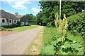
Roadside Rhubarb
There should be a lot more Rheum rhabarbarum adding panache to our roadside verges.
Eye-catching, stylish and good with custard, which is more than can be said for nettles.
Image: © Des Blenkinsopp
Taken: 15 Jun 2015
0.02 miles
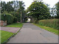
2
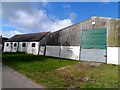
Severalles Farm, Ilmer
"Ilmere" is recorded in the Domesday Book. Ilmer is a tiny hamlet but had its own railway station, Ilmer Halt, until 1963.
Image: © Bikeboy
Taken: 23 Mar 2014
0.04 miles
3
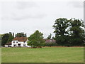
"The Severalls" farm, Ilmer
View across the fields from Swan's way
Image: © David Hawgood
Taken: 4 Aug 2005
0.07 miles
4
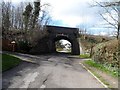
Railway bridge, Ilmer
Carrying the Chiltern Main Line which opened between 1899 and 1905 as The Great Western and Great Central Joint Railway
Image: © Bikeboy
Taken: 23 Mar 2014
0.07 miles
5
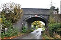
Bridge 103 at Ilmer
GWR & GCR Joint Line bridge No. 103 was built in the early 1900's across the road to Ilmer from what is now the A4129 from Princes Risborough to Thame.
Image: © Bob Walters
Taken: 10 Nov 2021
0.08 miles
6
Lane heading under railway bridge
Lane (Swans Way) heading under railway bridge to Ilmer
Image: © Shaun Ferguson
Taken: 3 Oct 2008
0.08 miles
7
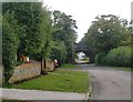
Minor road and railway bridge at Ilmer
Approaching Ilmer from the north-east, along the only road that reaches the village. The bridge carries the Paddington-Birmingham main line.
Image: © Stefan Czapski
Taken: 26 Aug 2014
0.09 miles
8
The approach to Ilmer church (1)
As you see it when approaching along the village street from the north-east. For a fuller view of the church, see: http://www.geograph.org.uk/photo/4141357
Image: © Stefan Czapski
Taken: 26 Aug 2014
0.10 miles
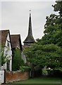
9
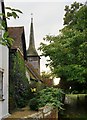
The approach to Ilmer church (2)
I was reminded of the shingled spire of a rather remote church in Lincolnshire: Image
Image: © Stefan Czapski
Taken: 26 Aug 2014
0.11 miles
10
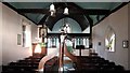
Interior of St Peter's, Ilmer
Looking east from behind the font to the chancel with both screen and arch of timber and a wagon roof.
Image: © Chris Brown
Taken: 13 Feb 2017
0.12 miles