IMAGES TAKEN NEAR TO
North Mill Road, PRINCES RISBOROUGH, HP27 9QP
Introduction
This page details the photographs taken nearby to North Mill Road, HP27 9QP by members of the Geograph project.
The Geograph project started in 2005 with the aim of publishing, organising and preserving representative images for every square kilometre of Great Britain, Ireland and the Isle of Man.

There are currently over 7.5m images from over14,400 individuals and you can help contribute to the project by visiting https://www.geograph.org.uk
Image Map
Images are licensed for reuse under creativecommons.org/licenses/by-sa/2.0
Notes
- Clicking on the map will re-center to the selected point.
- The higher the marker number, the further away the image location is from the centre of the postcode.
Image Listing (10 Images Found)
Images are licensed for reuse under creativecommons.org/licenses/by-sa/2.0
Image
Details
Distance
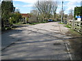
2
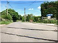
Level Crossing - Still There
For some reason, nostalgia, economy, laziness or whatever, this short length of the original train track has been left here in the road years after the rest of the line has been dismantled and turned into a cycleway.
Image: © Des Blenkinsopp
Taken: 19 May 2014
0.11 miles
3
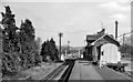
Bledlow Station
View eastward, towards Princes Risborough and London; ex-GWR Princes Risborough - Thame - Oxford line. Station closed with passenger traffic on line 7/1/63, but line remained open (for oil traffic to Thame) until 17/4/91.
Image: © Ben Brooksbank
Taken: 24 Mar 1961
0.12 miles
4
Bledlow Railway Station, Bucks
This railway station in Sandpit Lane was situated on the railway line between Princes Risborough and Oxford which closed in early January, 1963. Following closure, it then became a Bed and Breakfast establishment "The Old Station" although that has now closed. The track was lifted some while ago and has since been converted into the Phoenix cycle trail. Its postcode is HP27 9QQ.
Image: © David Hillas
Taken: 1 Sep 1969
0.12 miles
5

Former Bledlow Station at Old Ford
This was Bledlow Station on the Thame to Princes Risborough railway, with a level crossing. The disused railway is now a cycle track, which is diverted around this short section which is a private house and garden.
Image: © David Hawgood
Taken: 2 Aug 2005
0.13 miles
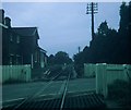
6
Bledlow: Sandpit Lane disused level crossing
The former Princes Risborough to Oxford railway line crossed Sandpit Lane at this point. The railway was opened in 1863, but the through route was closed in 1967, leaving open only the section, including this level crossing, from the junction with the Watlington branch line to Thame to serve the oil depot there. In 1991 that section was closed and the track subsequently lifted, apart from a few odd places, this level crossing site being one of them. The former Bledlow station is immediately to the left.
Image: © Nigel Cox
Taken: 30 Mar 2008
0.13 miles
7
Phoenix Trail Seating
As befits a leisure facility like the Phoenix Trail cycleway, a lot of attention has been paid to sitting down as well as taking exercise.
Designer seating, sometimes quite elaborate and artistic, has been installed at regular intervals along the route.
Image: © Des Blenkinsopp
Taken: 19 May 2014
0.15 miles
8
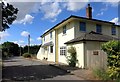
The Old Seven Stars
Over the road from the former Bledlow Station.
Image: © Des Blenkinsopp
Taken: 7 Jul 2015
0.18 miles
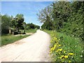
9

Phoenix trail at Sandpit lane
Phoenix trail at Sandpit lane slightly diverted off the former track bed which is now the garden off the nearby house
Image: © Shaun Ferguson
Taken: 19 Oct 2008
0.18 miles
10
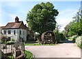
Water Wheel on the Corner
The remains of some of the old machinery, including the mill wheel, are on display here at the end of North Mill Road.
Image: © Des Blenkinsopp
Taken: 19 May 2014
0.23 miles