IMAGES TAKEN NEAR TO
Summerleys Road, PRINCES RISBOROUGH, HP27 9QD
Introduction
This page details the photographs taken nearby to Summerleys Road, HP27 9QD by members of the Geograph project.
The Geograph project started in 2005 with the aim of publishing, organising and preserving representative images for every square kilometre of Great Britain, Ireland and the Isle of Man.

There are currently over 7.5m images from over14,400 individuals and you can help contribute to the project by visiting https://www.geograph.org.uk
Image Map
Images are licensed for reuse under creativecommons.org/licenses/by-sa/2.0
Notes
- Clicking on the map will re-center to the selected point.
- The higher the marker number, the further away the image location is from the centre of the postcode.
Image Listing (8 Images Found)
Images are licensed for reuse under creativecommons.org/licenses/by-sa/2.0
Image
Details
Distance
1
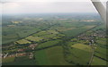
Railway Juncrtion west of Princes Risborough: aerial 2015
Image: © Chris
Taken: 14 Jun 2015
0.10 miles
2
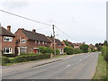
Houses on B4444, Princes Risborough
Just at the Western edge of the town
Image: © David Hawgood
Taken: 4 Aug 2005
0.14 miles
3
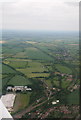
Railway Junction west of Princes Risborough: aerial 2015
Image: © Chris
Taken: 14 Jun 2015
0.14 miles
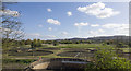
4
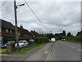
Back Way From Princes Risborough
An alternative route north from the town, handy for the station area.
Image: © Peter Whatley
Taken: 28 May 2009
0.18 miles
5
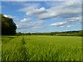
Farmland, Princes Risborough
A crop of barley beside a footpath to the northwest of the town.
Image: © Andrew Smith
Taken: 20 May 2011
0.19 miles
7
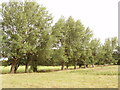
Trees by B4444, Princes Risborough
The edge of open agricultural country, a row of trees between fields
Image: © David Hawgood
Taken: 4 Aug 2005
0.22 miles
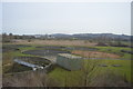
8
Sewage Works
Looking ENE from the railway line across the sewage works.
Image: © David P Howard
Taken: 13 Apr 2014
0.23 miles