IMAGES TAKEN NEAR TO
Church End, PRINCES RISBOROUGH, HP27 9PB
Introduction
This page details the photographs taken nearby to Church End, HP27 9PB by members of the Geograph project.
The Geograph project started in 2005 with the aim of publishing, organising and preserving representative images for every square kilometre of Great Britain, Ireland and the Isle of Man.

There are currently over 7.5m images from over14,400 individuals and you can help contribute to the project by visiting https://www.geograph.org.uk
Image Map
Images are licensed for reuse under creativecommons.org/licenses/by-sa/2.0
Notes
- Clicking on the map will re-center to the selected point.
- The higher the marker number, the further away the image location is from the centre of the postcode.
Image Listing (61 Images Found)
Images are licensed for reuse under creativecommons.org/licenses/by-sa/2.0
Image
Details
Distance
1
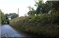
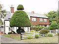
Bledlow Village
Houses in the village of Bledlow.
Image: © Wayland Smith
Taken: 12 Sep 2021
0.01 miles
2
Houses on the Corner
A couple of houses and a mail van the east end of Bledlow village.
Image: © Des Blenkinsopp
Taken: 17 Feb 2015
0.02 miles
3
Renovation at Bledlow Homes
Pictures from a few years ago, Image( see for info) and Image show this lovely old range of buildings in a sad and derelict condition.
This view of the southern aspect shows that work seems to have started on doing the place up at last.
Image: © Des Blenkinsopp
Taken: 17 Feb 2015
0.06 miles
4
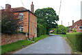
Houses in Bledlow
On the road with the church, near the top of the village
Image: © David Hawgood
Taken: 4 Aug 2005
0.06 miles
5
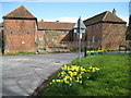
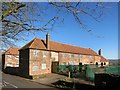
Bledlow Homes
This large U-shaped building, at the east end of Church End, is known as Bledlow Homes, but was formerly the parish workhouse, built around 1800 to house 180 inmates. It later became the Wycombe Union School for Boys and Girls. The 1881 Census lists about 56 resident children aged between 5 and 15 under the tutelage of the Master, George Roberts, with his sister Rebecca who was the Matron. The Ordnance Survey map of 1922 still shows the building as Wycombe Union School.
The building, which is listed but abandoned, appears to be currently owned by Buckinghamshire County Council (for theirs is the small white notice on the left warning persons not to trespass because of the dangerous state of the structure).
(Apologies for the road sign in the middle of this photograph - I could not get a view of the whole building and the whole courtyard from any other angle!)
Image: © Nigel Cox
Taken: 30 Mar 2008
0.06 miles
6
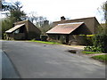
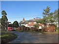
Bledlow: Church End modern houses
This small housing development, in Church End opposite the Manor House and immediately above The Lyde Garden, was designed by the architectural practice of Aldington Craig + Collinge http://www.aldingtoncraigandcollinge.co.uk/ in the 1970s. It won an award from the Royal Institution of British Architects. The award committee was impressed with the quality and detail of the design and the simplicity of the materials, and also were of the opinion that a pleasant sense of scale and enclosure had been created and that the interesting silhouette did not jar with the traditional types of houses nearby.
Image: © Nigel Cox
Taken: 30 Mar 2008
0.07 miles
7
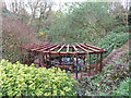
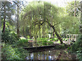
Carington Estate's Lyde Garden in Bledlow
Image: © Gareth James
Taken: 2 Apr 2022
0.07 miles
8
Carington Estate's Lyde Garden in Bledlow
Image: © Gareth James
Taken: 2 Apr 2022
0.08 miles
9
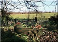
Carving on the Compost Heap
This in a corner of The Lyde Garden, a beautiful water garden set round a group of springs in a hollow at the source of the River Lyde.
Damp and decay have taken their toll on this wooden carving, which has rotted away at the base and been unceremoniously thrown on the tip.
Lying like this it looks like a sort of creepy grasshopper thing, but I think it originally was upright as a sort of tree sculpture.
Image: © Des Blenkinsopp
Taken: 17 Feb 2015
0.09 miles