IMAGES TAKEN NEAR TO
Bledlow Road, PRINCES RISBOROUGH, HP27 9NH
Introduction
This page details the photographs taken nearby to Bledlow Road, HP27 9NH by members of the Geograph project.
The Geograph project started in 2005 with the aim of publishing, organising and preserving representative images for every square kilometre of Great Britain, Ireland and the Isle of Man.

There are currently over 7.5m images from over14,400 individuals and you can help contribute to the project by visiting https://www.geograph.org.uk
Image Map (Loading...)


Getting Data...Please wait
Leaflet Map data © OpenStreetMap
Images are licensed for reuse under creativecommons.org/licenses/by-sa/2.0
Notes
- Clicking on the map will re-center to the selected point.
- The higher the marker number, the further away the image location is from the centre of the postcode.
Image Listing (5 Images Found)
Images are licensed for reuse under creativecommons.org/licenses/by-sa/2.0
Image
Details
Distance
1
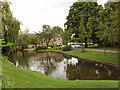
Nursing Home and pond, Saunderton
This is the large Cherry Tree Nursing Home. Taken from the road between this and another section of the pond, in Church Farm
Image: © David Hawgood
Taken: 12 Aug 2005
0.07 miles
2
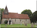
Church of St Mary and St Nicholas, Saunderton
Two churches in the parish were combined into one about 1450. The church was restored in 1887/8 with retention of some old fragments.
Image: © David Hawgood
Taken: 12 Aug 2005
0.07 miles