IMAGES TAKEN NEAR TO
Westmead, PRINCES RISBOROUGH, HP27 9HR
Introduction
This page details the photographs taken nearby to Westmead, HP27 9HR by members of the Geograph project.
The Geograph project started in 2005 with the aim of publishing, organising and preserving representative images for every square kilometre of Great Britain, Ireland and the Isle of Man.

There are currently over 7.5m images from over14,400 individuals and you can help contribute to the project by visiting https://www.geograph.org.uk
Image Map
Images are licensed for reuse under creativecommons.org/licenses/by-sa/2.0
Notes
- Clicking on the map will re-center to the selected point.
- The higher the marker number, the further away the image location is from the centre of the postcode.
Image Listing (11 Images Found)
Images are licensed for reuse under creativecommons.org/licenses/by-sa/2.0
Image
Details
Distance
1
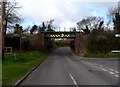
Railway bridge, Monks Risborough
Single track railway which opened in 1868.
Image: © Bikeboy
Taken: 23 Mar 2014
0.10 miles
2
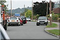
Wellington Avenue
Typical congestion at 3pm on a school day!
Image: © Tim S Addison
Taken: 7 Sep 2007
0.14 miles
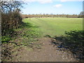
3
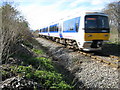
Monks Risborough: Railway line from Princes Risborough
A northbound Chiltern Railways train from Princes Risborough heading for Aylesbury is about to cross the pedestrian crossing from Westmead to Alscot Farm.
Image: © Nigel Cox
Taken: 30 Mar 2008
0.14 miles
4

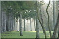
April snow King George V playing field
A late snowfall covered the Corsican pines and other trees on the north eastern border of the King George V playing field in Princes Risborough.
Image: © Tim S Addison
Taken: 6 Apr 2008
0.15 miles
5
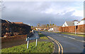
Shortborough Avenue, Monks Risborough
Monks Risborough and Princes Risborough were originally separate communities but are now joined together by suburban housing.
Image: © Des Blenkinsopp
Taken: 19 Dec 2020
0.16 miles
6
Morning Mist King George V Playing Field
Image: © Tim S Addison
Taken: 27 Dec 2008
0.18 miles
7
Monks Risborough: Footpath to Alscot Farm and Chadwell Hill
Viewed from the pedestrian crossing over the railway at the rear of Westmead.
Image: © Nigel Cox
Taken: 30 Mar 2008
0.21 miles
8
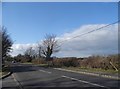
Leaving Princes Risborough on Longwick Road
Image: © David Howard
Taken: 20 Mar 2016
0.22 miles
9
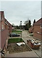
New houses in Princes Risborough
A view along the row of houses that form a new development of six properties by builders Matthew Homes Ltd in Princes Risborough. The view is from the first storey of the show home (Plot 2) looking northwestwards. As can be seen from the skip and muddy front garden, the site is yet to be completed.
The development replaces a single large house previously on the site, called "Longfield".
Image: © Rob Farrow
Taken: 4 Apr 2015
0.23 miles
10
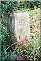
Old Milestone by the A4129 in Princes Risborough
Carved stone post by the A4129, in parish of Princes Risborough (Wycombe District), Longwick Road, Alscot, near sign for Princes Risborough, on the verge between road and ditch, on South side of road. Thame stone, erected by the Princes Risborough & Thame turnpike trust in the 19th century.
Inscription once read:-
: (Thame / 6½) : : (Princes Risborough / ½) :
Buckinghamshire HER.
HER Number: 1422200000 https://www.heritagegateway.org.uk/Gateway/Results_Single.aspx?uid=MBC32791&resourceID=1024
Milestone Society National ID: BU_THRI06
Image: © A Rosevear
Taken: 3 Sep 2002
0.23 miles