IMAGES TAKEN NEAR TO
Brooke Road, PRINCES RISBOROUGH, HP27 9HH
Introduction
This page details the photographs taken nearby to Brooke Road, HP27 9HH by members of the Geograph project.
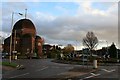
The Geograph project started in 2005 with the aim of publishing, organising and preserving representative images for every square kilometre of Great Britain, Ireland and the Isle of Man.

There are currently over 7.5m images from over14,400 individuals and you can help contribute to the project by visiting https://www.geograph.org.uk
Image Map
Images are licensed for reuse under creativecommons.org/licenses/by-sa/2.0
Notes
- Clicking on the map will re-center to the selected point.
- The higher the marker number, the further away the image location is from the centre of the postcode.
Image Listing (61 Images Found)
Images are licensed for reuse under creativecommons.org/licenses/by-sa/2.0
Image
Details
Distance
1
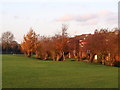
The Brook
One of the many streams starting in the chalk of the Chiltern Hills runs alongside Wades Field with pollarded willow trees growing on its bank. The houses are at the end of the neighbouring Brook Road.
Image: © Tim S Addison
Taken: 11 Nov 2008
0.10 miles
2
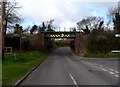
Railway bridge, Monks Risborough
Single track railway which opened in 1868.
Image: © Bikeboy
Taken: 23 Mar 2014
0.11 miles
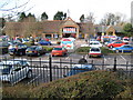
3
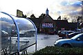
Tesco, Princes Risborough
With a frontage finished in the local vernacular.
Image: © David Lally
Taken: 25 Nov 2009
0.11 miles
4
Princes Risborough: Tesco
The Tesco store is inside the Princes Risborough Conservation Area. Wycombe District Council's Conservation Area notes describe it thus:
"The east part of Area 1 is occupied by the new Tesco supermarket which uses clay roof tiles, good bricks, some flint and natural slate to good effect. It replaced a garage and a 1930s public house in a poor neo-Georgian style and its car park is surrounded by brick walls west of the access and ornamental railings beyond. It is a successful building, only marred by the large sign within the glazed arch."
The beige tablet in the gable end has the date 1996.
Image: © Nigel Cox
Taken: 30 Mar 2008
0.13 miles
5
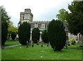
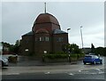
St Teresa of the Child Jesus
On the edge of the centre of Princes Risborough.
Image: © David Lally
Taken: 25 Nov 2009
0.15 miles
6
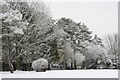
April snow King George V playing field
A late snowfall covered the Corsican pines and other trees on the north eastern border of the King George V playing field in Princes Risborough.
Image: © Tim S Addison
Taken: 6 Apr 2008
0.15 miles
7
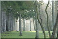
Morning Mist King George V Playing Field
Image: © Tim S Addison
Taken: 27 Dec 2008
0.15 miles
9
St Teresa's RC Church, Princes Risborough: May 2021
Image: © Basher Eyre
Taken: 23 May 2021
0.16 miles
10
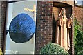
Statue of St Teresa
On the catholic chrurch dedicated to her in Princes Risborough.
Image: © David Lally
Taken: 25 Nov 2009
0.16 miles