IMAGES TAKEN NEAR TO
Fairway, PRINCES RISBOROUGH, HP27 9DH
Introduction
This page details the photographs taken nearby to Fairway, HP27 9DH by members of the Geograph project.
The Geograph project started in 2005 with the aim of publishing, organising and preserving representative images for every square kilometre of Great Britain, Ireland and the Isle of Man.

There are currently over 7.5m images from over14,400 individuals and you can help contribute to the project by visiting https://www.geograph.org.uk
Image Map
Images are licensed for reuse under creativecommons.org/licenses/by-sa/2.0
Notes
- Clicking on the map will re-center to the selected point.
- The higher the marker number, the further away the image location is from the centre of the postcode.
Image Listing (41 Images Found)
Images are licensed for reuse under creativecommons.org/licenses/by-sa/2.0
Image
Details
Distance
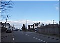
1
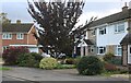
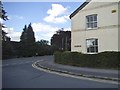
Fairway, Princes Risborough
Houses on Fairway seen from the junction with Manor Park Avenue.
Image: © Stephen McKay
Taken: 24 Oct 2018
0.04 miles
3
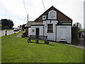
Princes Risborough: The former British School
The British School was established in the Parkfield area of Princes Risborough in 1836. It is now used as a studio. The A4010 Wycombe Road is to the left and the B4444 Station Road to the right.
Image: © Nigel Cox
Taken: 30 Mar 2008
0.08 miles
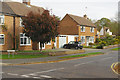
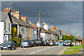
4
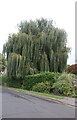
Willow tree on Stratton Road, Princes Risborough
Image: © David Howard
Taken: 27 Sep 2022
0.08 miles
5
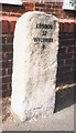
Old Milestone by the A4010 in Princes Risborough
Carved stone post by the A4010, in parish of Princes Risborough (Wycombe District), Wycombe Road; at junction with Station Road, outside old British School, now a design studio, in tarmac between grass verge and a low domestic boundary wall, on West side of road. Wycombe rough stone post, erected by the Ellesborough to West Wycombe turnpike trust in the 19th century.
Inscription reads:-
LONDON
37
WYCOMBE
8
Carved benchmark front base.
Buckinghamshire HER.
HER Number: 1352900000 https://www.heritagegateway.org.uk/Gateway/Results_Single.aspx?uid=MBC25356&resourceID=1024
Milestone Society National ID: BU_WYAY08
Image: © A Rosevear & J Higgins
Taken: 3 Sep 2002
0.09 miles
6
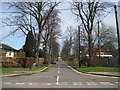
Princes Risborough: Manor Park Road
As seen from Station Road, the Ordnance Survey map of 1922 shows this tree-lined road as nothing more than a footpath.
Image: © Nigel Cox
Taken: 30 Mar 2008
0.10 miles
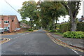
7
Houses on Stratton Road, Princes Risborough
Image: © David Howard
Taken: 27 Sep 2022
0.11 miles
8
Poppy Road at the junction of Station Road
Image: © David Howard
Taken: 10 Aug 2017
0.12 miles
9
Wycombe Road, Princes Risborough
The A4010 entering the town from the south.
Image: © Andrew Smith
Taken: 7 Nov 2010
0.12 miles