IMAGES TAKEN NEAR TO
Laurel Close, PRINCES RISBOROUGH, HP27 0UT
Introduction
This page details the photographs taken nearby to Laurel Close, HP27 0UT by members of the Geograph project.
The Geograph project started in 2005 with the aim of publishing, organising and preserving representative images for every square kilometre of Great Britain, Ireland and the Isle of Man.

There are currently over 7.5m images from over14,400 individuals and you can help contribute to the project by visiting https://www.geograph.org.uk
Image Map (Loading...)


Getting Data...Please wait
Leaflet Map data © OpenStreetMap
Images are licensed for reuse under creativecommons.org/licenses/by-sa/2.0
Notes
- Clicking on the map will re-center to the selected point.
- The higher the marker number, the further away the image location is from the centre of the postcode.
Image Listing (18 Images Found)
Images are licensed for reuse under creativecommons.org/licenses/by-sa/2.0
Image
Details
Distance
1
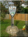
Speen village sign
Sign depicts traditional local industries of lace making and chair leg turning by bodgers
Image: © Peter Jemmett
Taken: 14 Oct 2007
0.04 miles

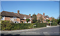
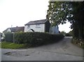
4
King William IV pub, Speen
There is written evidence that there was a pub here in 1668 but this building is C18. See http://www.britishlistedbuildings.co.uk/en-46346-king-william-iv-public-house-lacey-green- for entry in British Listed Buildings.
Image: © Bikeboy
Taken: 22 Mar 2015
0.09 miles
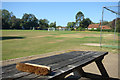
5
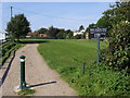
Speen playing field
Speen playing field off Hampden road next to King William IV pub
Image: © Shaun Ferguson
Taken: 20 Sep 2008
0.09 miles
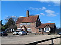
6
King William IV (closed)
No longer trading and just starting to look a bit dishevelled.
Image: © Des Blenkinsopp
Taken: 18 Sep 2019
0.10 miles
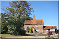
8
Flowers Bottom Lane at the junction of Grubbins Lane
Image: © David Howard
Taken: 10 Aug 2017
0.14 miles
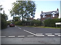
10
Coleheath Bottom
A bridleway to the east of the village. It also forms an access track to a number of houses as well as a convenient footpath route to Monkton Wood.
Image: © Graham Horn
Taken: 30 Apr 2011
0.15 miles