IMAGES TAKEN NEAR TO
Woodway, PRINCES RISBOROUGH, HP27 0NW
Introduction
This page details the photographs taken nearby to Woodway, HP27 0NW by members of the Geograph project.
The Geograph project started in 2005 with the aim of publishing, organising and preserving representative images for every square kilometre of Great Britain, Ireland and the Isle of Man.

There are currently over 7.5m images from over14,400 individuals and you can help contribute to the project by visiting https://www.geograph.org.uk
Image Map (Loading...)


Getting Data...Please wait
Leaflet Map data © OpenStreetMap
Images are licensed for reuse under creativecommons.org/licenses/by-sa/2.0
Notes
- Clicking on the map will re-center to the selected point.
- The higher the marker number, the further away the image location is from the centre of the postcode.
Image Listing (5 Images Found)
Images are licensed for reuse under creativecommons.org/licenses/by-sa/2.0
Image
Details
Distance
1
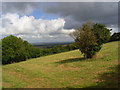
Hillside, Loosley Row
Pasture on the Chiltern scarp above the Aylesbury Vale.
Image: © Andrew Smith
Taken: 17 Aug 2008
0.04 miles
2
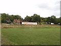
Farm at Loosley Row
From the road down into Princes Risborough.
Image: © David Hawgood
Taken: 30 Aug 2006
0.05 miles
4
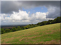
Hillside, Loosley Row
A line of pylons descends the partially wooded Chiltern scarp. The Aylesbury Vale is below.
Image: © Andrew Smith
Taken: 17 Aug 2008
0.10 miles
5
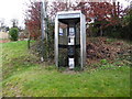
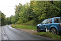
Former KX300 Telephone Kiosk at Loosley Row
Situated in Lower Road HP27 0PF, this telephone kiosk has a BT notice on the left hand side indicating that the kiosk will shortly be removed due to lack of usage. A No Smoking notice can just be seen below the payphone. Update: the telephone kiosk has since been removed.
Image: © David Hillas
Taken: 4 Jan 2017
0.19 miles