IMAGES TAKEN NEAR TO
Woodway, PRINCES RISBOROUGH, HP27 0NL
Introduction
This page details the photographs taken nearby to Woodway, HP27 0NL by members of the Geograph project.
The Geograph project started in 2005 with the aim of publishing, organising and preserving representative images for every square kilometre of Great Britain, Ireland and the Isle of Man.

There are currently over 7.5m images from over14,400 individuals and you can help contribute to the project by visiting https://www.geograph.org.uk
Image Map
Images are licensed for reuse under creativecommons.org/licenses/by-sa/2.0
Notes
- Clicking on the map will re-center to the selected point.
- The higher the marker number, the further away the image location is from the centre of the postcode.
Image Listing (6 Images Found)
Images are licensed for reuse under creativecommons.org/licenses/by-sa/2.0
Image
Details
Distance
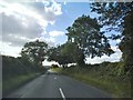
1
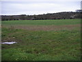
Looking across to Wardrobes
From Woodway looking across the fields to Wardrobes
Image: © Shaun Ferguson
Taken: 21 Nov 2008
0.04 miles
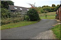
4
White Gate to Wardrobes
The house at the end of this drive is called Wardrobes.
I don't know why.
Image: © Des Blenkinsopp
Taken: 30 Mar 2016
0.21 miles
6
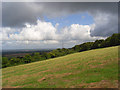
Hillside, Loosley Row
A line of pylons descends the partially wooded Chiltern scarp. The Aylesbury Vale is below.
Image: © Andrew Smith
Taken: 17 Aug 2008
0.23 miles