IMAGES TAKEN NEAR TO
Thorns Close, PRINCES RISBOROUGH, HP27 0LU
Introduction
This page details the photographs taken nearby to Thorns Close, HP27 0LU by members of the Geograph project.
The Geograph project started in 2005 with the aim of publishing, organising and preserving representative images for every square kilometre of Great Britain, Ireland and the Isle of Man.

There are currently over 7.5m images from over14,400 individuals and you can help contribute to the project by visiting https://www.geograph.org.uk
Image Map
Images are licensed for reuse under creativecommons.org/licenses/by-sa/2.0
Notes
- Clicking on the map will re-center to the selected point.
- The higher the marker number, the further away the image location is from the centre of the postcode.
Image Listing (8 Images Found)
Images are licensed for reuse under creativecommons.org/licenses/by-sa/2.0
Image
Details
Distance
1
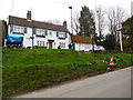
The Red Lion at Whiteleaf (1)
Situated in Whiteleaf HP27 0LL, this country pub dates from the 17th century and offers drinks and meals from Tuesdays to Sundays.
Image: © David Hillas
Taken: 13 Mar 2020
0.13 miles
2
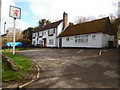
The Red Lion at Whiteleaf (2)
This photo shows The Red Lion which is situated on the Upper Icknield Way in Whiteleaf. This 17th century country pub offers drinks and meals except on Mondays.
Image: © David Hillas
Taken: 20 Mar 2020
0.14 miles
3
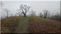
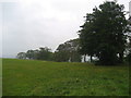
North End of Whiteleaf Hill
The tree ahead, like a lot round here, has thick ivy covering it's lower trunk.
Whiteleaf Hill Local Nature Reserve is one of 12 sites managed in the Chilterns by the Chiltern Society charity. Brush Hill Local Nature Reserve, another one of theirs, is situated adjacent to this one, on the other side of Peters Lane, the road leading up here from Monks Risborough.
The Chilterns are chalk hills situated NorthWest of London, covering an area of about 700 square miles, that run from NorthEast to Southwest. They drop steeply on the North side, and more gradually on the South towards the River Thames. The steep slopes to the North give rise to the range sometimes getting called the Chiltern Scarp or Escarpment. About half their area is designated as an Area of Outstanding Beauty.
Image: © Ian Dodds
Taken: 27 Dec 2021
0.18 miles
4
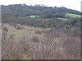
Woodland on the slopes of Whiteleaf Hill
Image: © Steve Daniels
Taken: 25 Aug 2009
0.19 miles
6
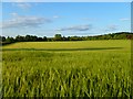
Farmland, Princes Risborough
A crop of barley on rising ground beside the A4010 below Whiteleaf.
Image: © Andrew Smith
Taken: 20 May 2011
0.22 miles
7
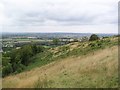
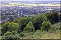
From Whiteleaf Cross towards Aylesbury vale.
Taken from the top of Whiteleaf Cross.
Image: © steve
Taken: 11 Aug 2008
0.22 miles
8
Whiteleaf Hill on a Wet Day
This is the summit of Whiteleaf Hill crossed by the Ridgeway - a fair lod persistant climb through woods from Lower Cadsden.
Image: © Chris Heaton
Taken: 1 Oct 2007
0.23 miles