IMAGES TAKEN NEAR TO
Brimmers Road, PRINCES RISBOROUGH, HP27 0LE
Introduction
This page details the photographs taken nearby to Brimmers Road, HP27 0LE by members of the Geograph project.
The Geograph project started in 2005 with the aim of publishing, organising and preserving representative images for every square kilometre of Great Britain, Ireland and the Isle of Man.

There are currently over 7.5m images from over14,400 individuals and you can help contribute to the project by visiting https://www.geograph.org.uk
Image Map
Images are licensed for reuse under creativecommons.org/licenses/by-sa/2.0
Notes
- Clicking on the map will re-center to the selected point.
- The higher the marker number, the further away the image location is from the centre of the postcode.
Image Listing (7 Images Found)
Images are licensed for reuse under creativecommons.org/licenses/by-sa/2.0
Image
Details
Distance
2
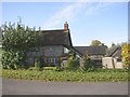
Farmhouse east of Princes Risborough
Brimmer Farmhouse and outbuildings
Image: © Roger
Taken: 27 Oct 2008
0.05 miles
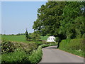
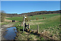
3
Stile near Brimmers Farm
Brimmers Farm on Brimmers Road is in the valley.
Image: © Des Blenkinsopp
Taken: 27 Feb 2022
0.07 miles
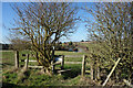
4
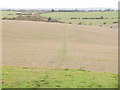
Footpath across a field leading to Brimmers Road
A steep footpath leads down through woodland from Redland End and emerges into the open to reveal this view ahead.
Image: © Peter S
Taken: 26 Nov 2011
0.14 miles
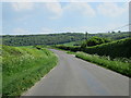
5
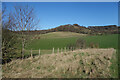
Windsor Hill
The Chiltern scarp near Princes Risborough.
Image: © Des Blenkinsopp
Taken: 27 Feb 2022
0.15 miles
6
Towards Windsor Hill
The Chiltern scarp near Princes Risborough.
Image: © Des Blenkinsopp
Taken: 27 Feb 2022
0.17 miles