IMAGES TAKEN NEAR TO
Upper Icknield Way, PRINCES RISBOROUGH, HP27 0EX
Introduction
This page details the photographs taken nearby to Upper Icknield Way, HP27 0EX by members of the Geograph project.
The Geograph project started in 2005 with the aim of publishing, organising and preserving representative images for every square kilometre of Great Britain, Ireland and the Isle of Man.

There are currently over 7.5m images from over14,400 individuals and you can help contribute to the project by visiting https://www.geograph.org.uk
Image Map
Images are licensed for reuse under creativecommons.org/licenses/by-sa/2.0
Notes
- Clicking on the map will re-center to the selected point.
- The higher the marker number, the further away the image location is from the centre of the postcode.
Image Listing (8 Images Found)
Images are licensed for reuse under creativecommons.org/licenses/by-sa/2.0
Image
Details
Distance
2
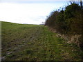
Field near Princes Risborough
This field is farmed and next to the Upper Icknield Way. The Shrub Land/Wood on the right is green belt but under threat of development
Image: © Graham Clutton
Taken: 1 Jan 2006
0.14 miles
3
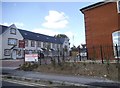
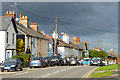
New houses on Poppy Road, Princes Risborough
Image: © David Howard
Taken: 10 Aug 2017
0.19 miles
4
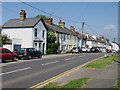
Houses on Wycombe Road, Princes Risborough
Image: © David Howard
Taken: 20 Mar 2016
0.20 miles
6
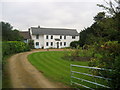
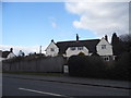
Culverton Manor
On the A4010 just outside the town of Princes Risborough, and passed by those walking the Ridgeway National Trail.
Image: © Chris Heaton
Taken: 1 Oct 2007
0.21 miles
8
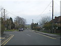
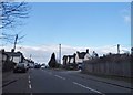
Wycombe Road, Princes Risborough
The A4010 entering the town from the south.
Image: © Andrew Smith
Taken: 7 Nov 2010
0.21 miles