IMAGES TAKEN NEAR TO
Cambrian Way, HEMEL HEMPSTEAD, HP2 5TB
Introduction
This page details the photographs taken nearby to Cambrian Way, HP2 5TB by members of the Geograph project.
The Geograph project started in 2005 with the aim of publishing, organising and preserving representative images for every square kilometre of Great Britain, Ireland and the Isle of Man.

There are currently over 7.5m images from over14,400 individuals and you can help contribute to the project by visiting https://www.geograph.org.uk
Image Map
Images are licensed for reuse under creativecommons.org/licenses/by-sa/2.0
Notes
- Clicking on the map will re-center to the selected point.
- The higher the marker number, the further away the image location is from the centre of the postcode.
Image Listing (16 Images Found)
Images are licensed for reuse under creativecommons.org/licenses/by-sa/2.0
Image
Details
Distance
1
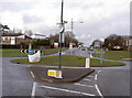
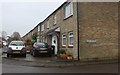
Aycliffe Drive & Link Road. Grovehill
Roundabout junction with the A4147 [Link Road], crossing left to right. Looking up into Aycliffe Drive, Grovehill, Hemel Hempstead.
Image: © Rob Emms
Taken: 12 Feb 2007
0.11 miles
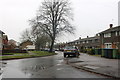
2
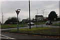
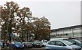
Roundabout on Link Road, Hemel Hempstead
Image: © David Howard
Taken: 23 Nov 2019
0.12 miles
3
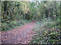
Hemel Hempstead: The Nicky Line
The trackbed of the dismantled Hemel Hempstead to Harpenden railway (The Nicky Line) viewed looking towards the centre of Hemel Hempstead. This is the approximate location of one of the intermediate stations along the route, Godwin's Halt, named after a prominent local landowner. The route is now a footpath and is also one of the few opened sections of the proposed National Cycle Network Route 57 that will eventually run from Cricklade in Wiltshire to Welwyn Garden City in Hertfordshire.
Image: © Nigel Cox
Taken: 14 Oct 2007
0.14 miles
4
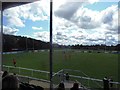
The View from the Stand, Pennine Way Stadium
Game in progress, Hemel Stags V Hunslet Hawks, Sunday 10th August, 2014.
Image: © Bill Henderson
Taken: 10 Aug 2014
0.16 miles
5
Saturn Way at the corner of Titan Road
There is a planetary theme on this area.
Image: © David Howard
Taken: 23 Nov 2019
0.17 miles
6
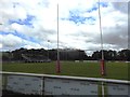
Pennine Way Sports Ground
The home of Hemel Stags Rugby League Football Club.
Image: © Bill Henderson
Taken: 10 Aug 2014
0.17 miles
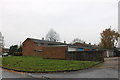
10
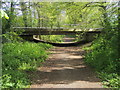
The Nickey Line
The Nickey Line passing under the Solway Road bridge, originally built in 1961 as part of the expansion of Hemel Hempstead. The cutting here was deeper originally, but was partly filled in in the mid-1960s (information from "The Harpenden to Hemel Hempstead Railway" by Sue and Geoff Woodward, Oakwood Press, 1996).
Image: © Shaun Ferguson
Taken: 30 Apr 2010
0.19 miles