IMAGES TAKEN NEAR TO
Westwick Row, HEMEL HEMPSTEAD, HP2 4UB
Introduction
This page details the photographs taken nearby to Westwick Row, HP2 4UB by members of the Geograph project.
The Geograph project started in 2005 with the aim of publishing, organising and preserving representative images for every square kilometre of Great Britain, Ireland and the Isle of Man.

There are currently over 7.5m images from over14,400 individuals and you can help contribute to the project by visiting https://www.geograph.org.uk
Image Map (Loading...)


Getting Data...Please wait
Leaflet Map data © OpenStreetMap
Images are licensed for reuse under creativecommons.org/licenses/by-sa/2.0
Notes
- Clicking on the map will re-center to the selected point.
- The higher the marker number, the further away the image location is from the centre of the postcode.
Image Listing (4 Images Found)
Images are licensed for reuse under creativecommons.org/licenses/by-sa/2.0
Image
Details
Distance
1
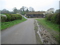
Westwick Row
Westwick Row is one of those places where the name of the place and the road are the same. In the dip is one of the outbuildings of Westwick Row Farm. In the 1883 Edition of the Ordnance Survey mapping the farm appeared as Westwickrow Farm, but from the 1899 through to the 1938 Editions it was shown as just Westwick Farm.
Image: © Nigel Cox
Taken: 12 Apr 2009
0.03 miles
2
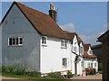
Westwick Row Farm
The M1 motorway passes very close to the house
Image: © Jack Hill
Taken: 15 Aug 2005
0.07 miles
3
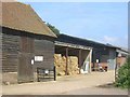
Westwick Row Farm
The farm yard has a neat and tidy appearance .perhaps due to its close proximity to the lane.
Image: © Jack Hill
Taken: 15 Aug 2005
0.11 miles
4
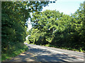
A4147, Hemel Hempstead Road
From St. Albans.
Image: © Robin Webster
Taken: 6 Sep 2015
0.24 miles