IMAGES TAKEN NEAR TO
Field Road, HEMEL HEMPSTEAD, HP2 4RX
Introduction
This page details the photographs taken nearby to Field Road, HP2 4RX by members of the Geograph project.
The Geograph project started in 2005 with the aim of publishing, organising and preserving representative images for every square kilometre of Great Britain, Ireland and the Isle of Man.

There are currently over 7.5m images from over14,400 individuals and you can help contribute to the project by visiting https://www.geograph.org.uk
Image Map
Images are licensed for reuse under creativecommons.org/licenses/by-sa/2.0
Notes
- Clicking on the map will re-center to the selected point.
- The higher the marker number, the further away the image location is from the centre of the postcode.
Image Listing (5 Images Found)
Images are licensed for reuse under creativecommons.org/licenses/by-sa/2.0
Image
Details
Distance
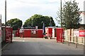
1
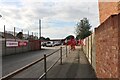
The entrance to Hemel Hempstead Town FC
Image: © David Howard
Taken: 4 Sep 2022
0.12 miles
2
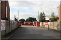
The entrance to Hemel Hempstead Town FC
Image: © David Howard
Taken: 4 Sep 2022
0.13 miles
4
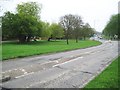
Adeyfield: Cox's Pond
Now filled in but it was in the green on the left side of the road. Originally there was a Coxpond Farm on the right side of the road, but this was swept away during the construction of Hemel Hempstead New Town in the 1950s. The pond lasted much longer. The road is Leverstock Green Road and in the 1930s and 1940s was the A4147, the A road classification having now passed to Maylands Road to the east.
Image: © Nigel Cox
Taken: 12 Apr 2009
0.20 miles
5
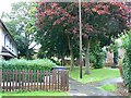
Belsize Close, Bennetts End, Hemel Hempstead
This part of the town was developed in the 1950s following the grant of 'New Town' status in the late 1940s. I found this on the local authority website for the area which encapsulates the post war history in a few words:
"The new town is one of the original 'Mark 1' types dating from the early
1950s. Today it has a population of approximately 81,000 (Census 2001).
Effectively it comprises a planned, linear town centre on the floor of the
Gade Valley with residential development extending up the valley sides.
Although important differences do exist, much of the housing is of a similar
size, design and layout, reflecting the original construction work carried out
by the Hemel Hempstead Development Corporation."
Image: © Brian Robert Marshall
Taken: 30 Sep 2008
0.24 miles