IMAGES TAKEN NEAR TO
Cholesbury, TRING, HP23 6NB
Introduction
This page details the photographs taken nearby to HP23 6NB by members of the Geograph project.
The Geograph project started in 2005 with the aim of publishing, organising and preserving representative images for every square kilometre of Great Britain, Ireland and the Isle of Man.

There are currently over 7.5m images from over14,400 individuals and you can help contribute to the project by visiting https://www.geograph.org.uk
Image Map (Loading...)


Getting Data...Please wait
Leaflet Map data © OpenStreetMap
Images are licensed for reuse under creativecommons.org/licenses/by-sa/2.0
Notes
- Clicking on the map will re-center to the selected point.
- The higher the marker number, the further away the image location is from the centre of the postcode.
Image Listing (42 Images Found)
Images are licensed for reuse under creativecommons.org/licenses/by-sa/2.0
Image
Details
Distance
2
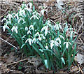
Clump of Snowdrops (Galanthus nivalis)
Dainty little snowdrops were growing in clumps amidst the bracken by the side of the road at Cholesbury Bottom. Note the little green inverted V at the base of the inner petals - this is a little store of chlorophyll which the plant has in its petals to help sustain it at a time of low sunlight, maximising its ability to photosynthesize. To see this clump in its setting, see Image
Image: © Rob Farrow
Taken: 11 Mar 2012
0.01 miles
3
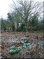
Snowdrops (Galanthus nivalis), Cholesbury Bottom
Sprouting merrily amidst the brown and crispy bracken, snowdrops herald Spring's arrival at Cholesbury Bottom. For a closer view, see Image]
Image: © Rob Farrow
Taken: 11 Mar 2012
0.01 miles
5

Footpath to Cholesbury Camp from Shire Lane
A Public Footpath sign in Shire Lane directs you to this path under the trees. Shire Lane lines on the boundary between Buckinghamshire and Hertfordshire.
Image: © Chris Reynolds
Taken: 11 Mar 2009
0.09 miles
6
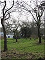
An Old Orchard near Cholesbury Camp
On the way from Shire Lane to the Camp you can see an old orchard over the fence. This area was part of a much larger orchard on the 1884 large scale Ordnance Survey map.
Image: © Chris Reynolds
Taken: 11 Mar 2009
0.09 miles
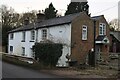
7
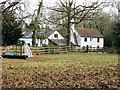
Old Houses at Cholesbury
This group of buildings (some possibly former barns) is marked on the 1884 Ordnance Survey – meaning that the houses are older than most of the other houses round the Camp.
Image: © Chris Reynolds
Taken: 11 Mar 2009
0.10 miles
8
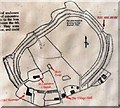
Cholesbury Camp ? Information Board
At this entrance to the Camp there is a large notice board with this map on it and a description, summarised below.
Cholesbury Camp is a large multivalate hill fort on the borders of Buckinghamshire and Hertfordshire. This kind of hillfort was constructed during the Iron Age (between 6th century BC and the time of the Roman invasion). They were mainly used as centre of permanent occupation and could be defended in response to increasing warfare. Here the earthen ramparts lie within the wooded belt which encircles all but the southern quarter, where the banks and ditches have been obscured by houses and gardens.
Two banks (internal and external) enclose a large ditch, which is the only defensive boundary to the north-east and north-west, but there are further banks and ditches to the west and south-east. The site is approximately oval, covering 10 acres and measuring approximately 310 m north-east to south west by 230 m north-west to south-east, with a level interior.
Excavations in 1932 in the interior of the hillfort uncovered well-preserved remains of prehistoric occupation including seven heaths or fire-sites, and the remains of a clay-lined oven. Three of the hearths showed evidence of iron smelting. Pottery has been dated as from 300 BC to 50 AD.
Image: © Chris Reynolds
Taken: 11 Mar 2009
0.11 miles
10
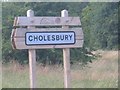
Village sign at Cholesbury
The sign indicates that the village is in the Chiltern Hills.
Image: © Jack Hill
Taken: 12 Jul 2005
0.13 miles